You are here: Home > Network List > IU - Global Seismograph Network (GSN - IRIS/USGS) Stations List
> Station PMG Port Moresby, New Guinea > Earthquake Result Viewer
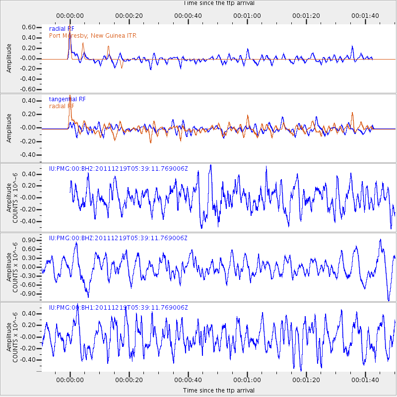
PMG Port Moresby, New Guinea - Earthquake Result Viewer
*The percent match for this event was below the threshold and hence no stack was calculated.
| Earthquake location: |
Kermadec Islands Region |
| Earthquake latitude/longitude: |
-29.1/-176.9 |
| Earthquake time(UTC): |
2011/12/19 (353) 05:32:16 GMT |
| Earthquake Depth: |
10 km |
| Earthquake Magnitude: |
5.7 MW, 5.5 MW |
| Earthquake Catalog/Contributor: |
NEIC PDE/NEIC PDE-M |
|
| Network: |
IU Global Seismograph Network (GSN - IRIS/USGS) |
| Station: |
PMG Port Moresby, New Guinea |
| Lat/Lon: |
9.40 S/147.16 E |
| Elevation: |
90 m |
|
| Distance: |
39.0 deg |
| Az: |
292.822 deg |
| Baz: |
125.146 deg |
| Ray Param: |
$rayparam |
*The percent match for this event was below the threshold and hence was not used in the summary stack. |
|
| Radial Match: |
63.020695 % |
| Radial Bump: |
400 |
| Transverse Match: |
55.159817 % |
| Transverse Bump: |
400 |
| SOD ConfigId: |
558545 |
| Insert Time: |
2013-09-19 08:48:11.499 +0000 |
| GWidth: |
2.5 |
| Max Bumps: |
400 |
| Tol: |
0.001 |
|
Signal To Noise
| Channel | StoN | STA | LTA |
| IU:PMG:00:BHZ:20111219T05:39:11.769006Z | 2.3287325 | 4.0058706E-7 | 1.7201936E-7 |
| IU:PMG:00:BH1:20111219T05:39:11.769006Z | 1.6928275 | 2.7152277E-7 | 1.6039601E-7 |
| IU:PMG:00:BH2:20111219T05:39:11.769006Z | 0.90607524 | 1.430915E-7 | 1.5792452E-7 |
| Arrivals |
| Ps | |
| PpPs | |
| PsPs/PpSs | |


