You are here: Home > Network List > IU - Global Seismograph Network (GSN - IRIS/USGS) Stations List
> Station HNR Honiara, Solomon Islands > Earthquake Result Viewer
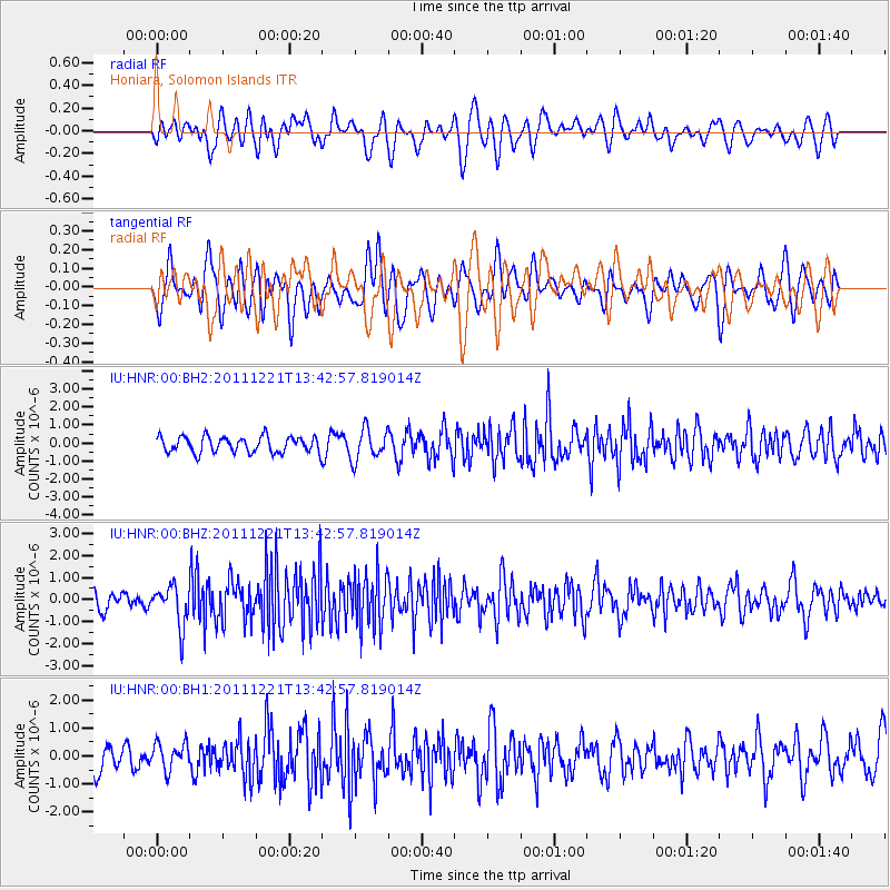
HNR Honiara, Solomon Islands - Earthquake Result Viewer
*The percent match for this event was below the threshold and hence no stack was calculated.
| Earthquake location: |
South Of Kermadec Islands |
| Earthquake latitude/longitude: |
-33.2/-179.0 |
| Earthquake time(UTC): |
2011/12/21 (355) 13:37:14 GMT |
| Earthquake Depth: |
10 km |
| Earthquake Magnitude: |
5.6 MB, 5.4 MS, 5.5 MW, 5.7 MW |
| Earthquake Catalog/Contributor: |
WHDF/NEIC |
|
| Network: |
IU Global Seismograph Network (GSN - IRIS/USGS) |
| Station: |
HNR Honiara, Solomon Islands |
| Lat/Lon: |
9.44 S/159.95 E |
| Elevation: |
100 m |
|
| Distance: |
30.6 deg |
| Az: |
315.85 deg |
| Baz: |
143.693 deg |
| Ray Param: |
$rayparam |
*The percent match for this event was below the threshold and hence was not used in the summary stack. |
|
| Radial Match: |
53.147583 % |
| Radial Bump: |
400 |
| Transverse Match: |
53.26148 % |
| Transverse Bump: |
400 |
| SOD ConfigId: |
558545 |
| Insert Time: |
2013-09-19 08:52:33.618 +0000 |
| GWidth: |
2.5 |
| Max Bumps: |
400 |
| Tol: |
0.001 |
|
Signal To Noise
| Channel | StoN | STA | LTA |
| IU:HNR:00:BHZ:20111221T13:42:57.819014Z | 2.4102075 | 8.992813E-7 | 3.7311364E-7 |
| IU:HNR:00:BH1:20111221T13:42:57.819014Z | 1.1942202 | 4.7497662E-7 | 3.977295E-7 |
| IU:HNR:00:BH2:20111221T13:42:57.819014Z | 1.9326092 | 8.53293E-7 | 4.415238E-7 |
| Arrivals |
| Ps | |
| PpPs | |
| PsPs/PpSs | |


