You are here: Home > Network List > IU - Global Seismograph Network (GSN - IRIS/USGS) Stations List
> Station PMG Port Moresby, New Guinea > Earthquake Result Viewer
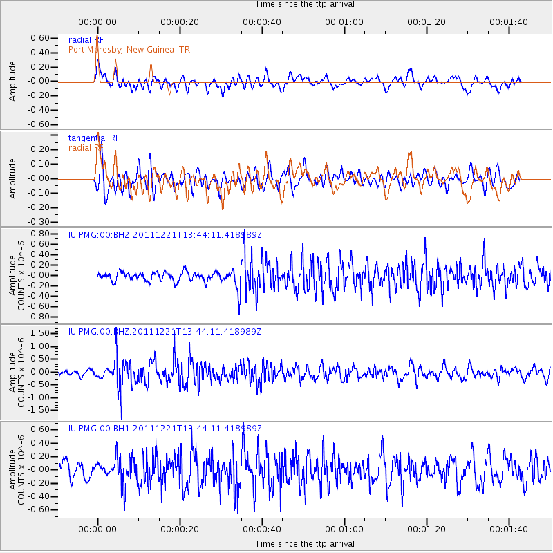
PMG Port Moresby, New Guinea - Earthquake Result Viewer
*The percent match for this event was below the threshold and hence no stack was calculated.
| Earthquake location: |
South Of Kermadec Islands |
| Earthquake latitude/longitude: |
-33.2/-179.0 |
| Earthquake time(UTC): |
2011/12/21 (355) 13:37:14 GMT |
| Earthquake Depth: |
10 km |
| Earthquake Magnitude: |
5.6 MB, 5.4 MS, 5.5 MW, 5.7 MW |
| Earthquake Catalog/Contributor: |
WHDF/NEIC |
|
| Network: |
IU Global Seismograph Network (GSN - IRIS/USGS) |
| Station: |
PMG Port Moresby, New Guinea |
| Lat/Lon: |
9.40 S/147.16 E |
| Elevation: |
90 m |
|
| Distance: |
39.1 deg |
| Az: |
299.459 deg |
| Baz: |
132.26 deg |
| Ray Param: |
$rayparam |
*The percent match for this event was below the threshold and hence was not used in the summary stack. |
|
| Radial Match: |
71.34906 % |
| Radial Bump: |
400 |
| Transverse Match: |
66.54587 % |
| Transverse Bump: |
400 |
| SOD ConfigId: |
558545 |
| Insert Time: |
2013-09-19 08:52:51.612 +0000 |
| GWidth: |
2.5 |
| Max Bumps: |
400 |
| Tol: |
0.001 |
|
Signal To Noise
| Channel | StoN | STA | LTA |
| IU:PMG:00:BHZ:20111221T13:44:11.418989Z | 4.1789756 | 4.4388364E-7 | 1.0621829E-7 |
| IU:PMG:00:BH1:20111221T13:44:11.418989Z | 1.030951 | 1.2429108E-7 | 1.2055963E-7 |
| IU:PMG:00:BH2:20111221T13:44:11.418989Z | 2.459283 | 2.0074778E-7 | 8.162858E-8 |
| Arrivals |
| Ps | |
| PpPs | |
| PsPs/PpSs | |


