You are here: Home > Network List > IU - Global Seismograph Network (GSN - IRIS/USGS) Stations List
> Station HNR Honiara, Solomon Islands > Earthquake Result Viewer
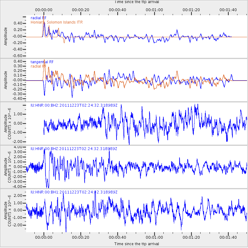
HNR Honiara, Solomon Islands - Earthquake Result Viewer
*The percent match for this event was below the threshold and hence no stack was calculated.
| Earthquake location: |
South Island, New Zealand |
| Earthquake latitude/longitude: |
-43.5/172.7 |
| Earthquake time(UTC): |
2011/12/23 (357) 02:18:03 GMT |
| Earthquake Depth: |
6.9 km |
| Earthquake Magnitude: |
5.7 MB, 5.6 MS, 5.9 MW, 5.8 MW |
| Earthquake Catalog/Contributor: |
WHDF/NEIC |
|
| Network: |
IU Global Seismograph Network (GSN - IRIS/USGS) |
| Station: |
HNR Honiara, Solomon Islands |
| Lat/Lon: |
9.44 S/159.95 E |
| Elevation: |
100 m |
|
| Distance: |
35.7 deg |
| Az: |
338.036 deg |
| Baz: |
163.995 deg |
| Ray Param: |
$rayparam |
*The percent match for this event was below the threshold and hence was not used in the summary stack. |
|
| Radial Match: |
52.553295 % |
| Radial Bump: |
400 |
| Transverse Match: |
53.890953 % |
| Transverse Bump: |
400 |
| SOD ConfigId: |
558545 |
| Insert Time: |
2013-09-19 08:56:16.769 +0000 |
| GWidth: |
2.5 |
| Max Bumps: |
400 |
| Tol: |
0.001 |
|
Signal To Noise
| Channel | StoN | STA | LTA |
| IU:HNR:00:BHZ:20111223T02:24:32.318989Z | 7.247028 | 2.6306184E-6 | 3.6299272E-7 |
| IU:HNR:00:BH1:20111223T02:24:32.318989Z | 2.4274187 | 1.1356191E-6 | 4.678299E-7 |
| IU:HNR:00:BH2:20111223T02:24:32.318989Z | 2.3550909 | 8.8203825E-7 | 3.745241E-7 |
| Arrivals |
| Ps | |
| PpPs | |
| PsPs/PpSs | |


