You are here: Home > Network List > IU - Global Seismograph Network (GSN - IRIS/USGS) Stations List
> Station PMG Port Moresby, New Guinea > Earthquake Result Viewer
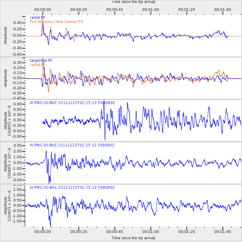
PMG Port Moresby, New Guinea - Earthquake Result Viewer
*The percent match for this event was below the threshold and hence no stack was calculated.
| Earthquake location: |
South Island, New Zealand |
| Earthquake latitude/longitude: |
-43.5/172.7 |
| Earthquake time(UTC): |
2011/12/23 (357) 02:18:03 GMT |
| Earthquake Depth: |
6.9 km |
| Earthquake Magnitude: |
5.7 MB, 5.6 MS, 5.9 MW, 5.8 MW |
| Earthquake Catalog/Contributor: |
WHDF/NEIC |
|
| Network: |
IU Global Seismograph Network (GSN - IRIS/USGS) |
| Station: |
PMG Port Moresby, New Guinea |
| Lat/Lon: |
9.40 S/147.16 E |
| Elevation: |
90 m |
|
| Distance: |
40.6 deg |
| Az: |
319.148 deg |
| Baz: |
151.175 deg |
| Ray Param: |
$rayparam |
*The percent match for this event was below the threshold and hence was not used in the summary stack. |
|
| Radial Match: |
70.54771 % |
| Radial Bump: |
400 |
| Transverse Match: |
71.0939 % |
| Transverse Bump: |
400 |
| SOD ConfigId: |
558545 |
| Insert Time: |
2013-09-19 08:56:38.642 +0000 |
| GWidth: |
2.5 |
| Max Bumps: |
400 |
| Tol: |
0.001 |
|
Signal To Noise
| Channel | StoN | STA | LTA |
| IU:PMG:00:BHZ:20111223T02:25:13.568989Z | 6.9928184 | 1.5249193E-6 | 2.1806933E-7 |
| IU:PMG:00:BH1:20111223T02:25:13.568989Z | 5.5312123 | 6.839728E-7 | 1.2365695E-7 |
| IU:PMG:00:BH2:20111223T02:25:13.568989Z | 3.6252742 | 4.0973887E-7 | 1.13022864E-7 |
| Arrivals |
| Ps | |
| PpPs | |
| PsPs/PpSs | |


