You are here: Home > Network List > US - United States National Seismic Network Stations List
> Station MNTX Cornudas Mountains, Texas, USA > Earthquake Result Viewer
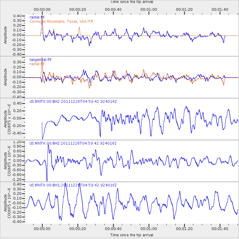
MNTX Cornudas Mountains, Texas, USA - Earthquake Result Viewer
*The percent match for this event was below the threshold and hence no stack was calculated.
| Earthquake location: |
Tonga Islands |
| Earthquake latitude/longitude: |
-16.2/-173.9 |
| Earthquake time(UTC): |
2011/12/26 (360) 04:48:08 GMT |
| Earthquake Depth: |
90 km |
| Earthquake Magnitude: |
5.8 MB, 6.0 MW, 6.0 MW |
| Earthquake Catalog/Contributor: |
WHDF/NEIC |
|
| Network: |
US United States National Seismic Network |
| Station: |
MNTX Cornudas Mountains, Texas, USA |
| Lat/Lon: |
31.70 N/105.38 W |
| Elevation: |
404 m |
|
| Distance: |
81.1 deg |
| Az: |
53.392 deg |
| Baz: |
244.8 deg |
| Ray Param: |
$rayparam |
*The percent match for this event was below the threshold and hence was not used in the summary stack. |
|
| Radial Match: |
53.584965 % |
| Radial Bump: |
400 |
| Transverse Match: |
37.839024 % |
| Transverse Bump: |
400 |
| SOD ConfigId: |
558545 |
| Insert Time: |
2013-09-19 09:04:30.111 +0000 |
| GWidth: |
2.5 |
| Max Bumps: |
400 |
| Tol: |
0.001 |
|
Signal To Noise
| Channel | StoN | STA | LTA |
| US:MNTX:00:BHZ:20111226T04:59:42.924016Z | 3.1943986 | 5.6267373E-7 | 1.7614386E-7 |
| US:MNTX:00:BH1:20111226T04:59:42.924016Z | 0.97230345 | 1.17205964E-7 | 1.2054463E-7 |
| US:MNTX:00:BH2:20111226T04:59:42.924016Z | 1.3147537 | 1.6596157E-7 | 1.2623016E-7 |
| Arrivals |
| Ps | |
| PpPs | |
| PsPs/PpSs | |


