You are here: Home > Network List > US - United States National Seismic Network Stations List
> Station WUAZ Wupatki, Arizona, USA > Earthquake Result Viewer
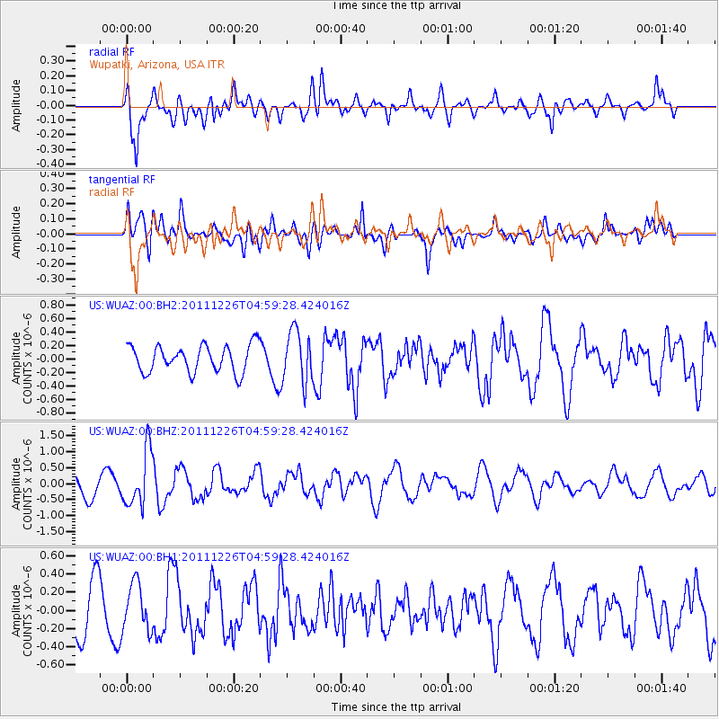
WUAZ Wupatki, Arizona, USA - Earthquake Result Viewer
*The percent match for this event was below the threshold and hence no stack was calculated.
| Earthquake location: |
Tonga Islands |
| Earthquake latitude/longitude: |
-16.2/-173.9 |
| Earthquake time(UTC): |
2011/12/26 (360) 04:48:08 GMT |
| Earthquake Depth: |
90 km |
| Earthquake Magnitude: |
5.8 MB, 6.0 MW, 6.0 MW |
| Earthquake Catalog/Contributor: |
WHDF/NEIC |
|
| Network: |
US United States National Seismic Network |
| Station: |
WUAZ Wupatki, Arizona, USA |
| Lat/Lon: |
35.52 N/111.37 W |
| Elevation: |
1592 m |
|
| Distance: |
78.4 deg |
| Az: |
47.622 deg |
| Baz: |
240.463 deg |
| Ray Param: |
$rayparam |
*The percent match for this event was below the threshold and hence was not used in the summary stack. |
|
| Radial Match: |
73.47021 % |
| Radial Bump: |
400 |
| Transverse Match: |
76.1437 % |
| Transverse Bump: |
400 |
| SOD ConfigId: |
558545 |
| Insert Time: |
2013-09-19 09:04:58.809 +0000 |
| GWidth: |
2.5 |
| Max Bumps: |
400 |
| Tol: |
0.001 |
|
Signal To Noise
| Channel | StoN | STA | LTA |
| US:WUAZ:00:BHZ:20111226T04:59:28.424016Z | 3.02407 | 8.797283E-7 | 2.909087E-7 |
| US:WUAZ:00:BH1:20111226T04:59:28.424016Z | 1.1167547 | 2.5723392E-7 | 2.3034058E-7 |
| US:WUAZ:00:BH2:20111226T04:59:28.424016Z | 1.930602 | 3.8597707E-7 | 1.9992576E-7 |
| Arrivals |
| Ps | |
| PpPs | |
| PsPs/PpSs | |


