You are here: Home > Network List > II - Global Seismograph Network (GSN - IRIS/IDA) Stations List
> Station KAPI Kappang, Sulawesi, Indonesia > Earthquake Result Viewer
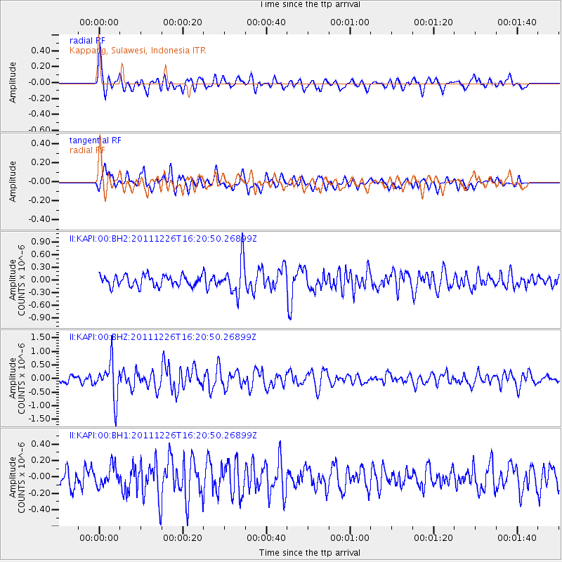
KAPI Kappang, Sulawesi, Indonesia - Earthquake Result Viewer
*The percent match for this event was below the threshold and hence no stack was calculated.
| Earthquake location: |
Vanuatu Islands |
| Earthquake latitude/longitude: |
-19.2/168.7 |
| Earthquake time(UTC): |
2011/12/26 (360) 16:12:33 GMT |
| Earthquake Depth: |
45 km |
| Earthquake Magnitude: |
5.5 MW, 5.6 MB, 5.6 MW |
| Earthquake Catalog/Contributor: |
NEIC PDE/NEIC PDE-M |
|
| Network: |
II Global Seismograph Network (GSN - IRIS/IDA) |
| Station: |
KAPI Kappang, Sulawesi, Indonesia |
| Lat/Lon: |
5.01 S/119.75 E |
| Elevation: |
300 m |
|
| Distance: |
49.7 deg |
| Az: |
279.924 deg |
| Baz: |
110.832 deg |
| Ray Param: |
$rayparam |
*The percent match for this event was below the threshold and hence was not used in the summary stack. |
|
| Radial Match: |
65.25933 % |
| Radial Bump: |
400 |
| Transverse Match: |
62.926098 % |
| Transverse Bump: |
400 |
| SOD ConfigId: |
558545 |
| Insert Time: |
2013-09-19 09:06:22.216 +0000 |
| GWidth: |
2.5 |
| Max Bumps: |
400 |
| Tol: |
0.001 |
|
Signal To Noise
| Channel | StoN | STA | LTA |
| II:KAPI:00:BHZ:20111226T16:20:50.26899Z | 3.9809992 | 6.969377E-7 | 1.7506602E-7 |
| II:KAPI:00:BH1:20111226T16:20:50.26899Z | 1.0658346 | 1.2332835E-7 | 1.1571059E-7 |
| II:KAPI:00:BH2:20111226T16:20:50.26899Z | 3.2021751 | 4.0799304E-7 | 1.2741121E-7 |
| Arrivals |
| Ps | |
| PpPs | |
| PsPs/PpSs | |


