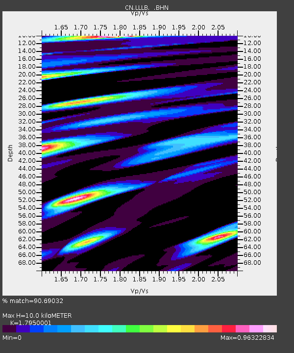
LLLB LILLOOET, BC, CANADA ADA - Earthquake Result Viewer
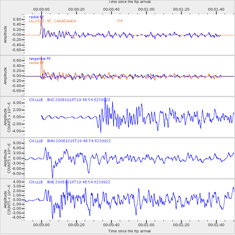
Earthquake location: Near Coast Of Chiapas, Mexico
Earthquake latitude/longitude: 14.4/-92.4
Earthquake time(UTC): 2008/10/16 (290) 19:41:25 GMT
Earthquake Depth: 24 km
Earthquake Magnitude: 6.1 MB, 6.6 MS, 6.7 MW, 6.6 MW
Earthquake Catalog/Contributor: WHDF/NEIC
Network: CN Canadian National Seismograph Network
Station: LLLB LILLOOET, BC, CANADA ADA
Lat/Lon: 50.61 N/121.88 W
Elevation: 700 m
Distance: 43.3 deg
Az: 332.75 deg
Baz: 135.873 deg
Ray Param: 0.07261234
Estimated Moho Depth: 10.0 km
Estimated Crust Vp/Vs: 1.80
Assumed Crust Vp: 6.597 km/s
Estimated Crust Vs: 3.675 km/s
Estimated Crust Poisson's Ratio: 0.27
Radial Match: 90.69032 %
Radial Bump: 400
Transverse Match: 82.80326 %
Transverse Bump: 400
SOD ConfigId: 2556
Insert Time: 2010-02-27 06:38:28.498 +0000
GWidth: 2.5
Max Bumps: 400
Tol: 0.001

Signal To Noise

ChannelStoNSTALTA
CN:LLLB: :BHN:20081016T19:48:54.623992Z8.4487362.5415434E-63.0081935E-7
CN:LLLB: :BHE:20081016T19:48:54.623992Z3.89875721.067614E-62.7383444E-7
CN:LLLB: :BHZ:20081016T19:48:54.623992Z6.30128241.5567936E-62.470598E-7
Arrivals
Ps1.3 SECOND
PpPs4.0 SECOND
PsPs/PpSs5.2 SECOND