You are here: Home > Network List > IU - Global Seismograph Network (GSN - IRIS/USGS) Stations List
> Station HNR Honiara, Solomon Islands > Earthquake Result Viewer
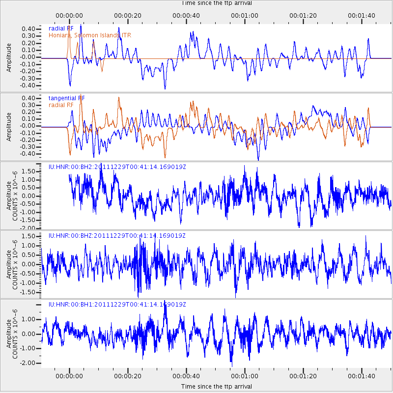
HNR Honiara, Solomon Islands - Earthquake Result Viewer
*The percent match for this event was below the threshold and hence no stack was calculated.
| Earthquake location: |
Pacific-Antarctic Ridge |
| Earthquake latitude/longitude: |
-58.4/-139.9 |
| Earthquake time(UTC): |
2011/12/29 (363) 00:30:54 GMT |
| Earthquake Depth: |
10 km |
| Earthquake Magnitude: |
5.6 MB |
| Earthquake Catalog/Contributor: |
NEIC PDE/NEIC PDE-M |
|
| Network: |
IU Global Seismograph Network (GSN - IRIS/USGS) |
| Station: |
HNR Honiara, Solomon Islands |
| Lat/Lon: |
9.44 S/159.95 E |
| Elevation: |
100 m |
|
| Distance: |
66.6 deg |
| Az: |
291.167 deg |
| Baz: |
150.169 deg |
| Ray Param: |
$rayparam |
*The percent match for this event was below the threshold and hence was not used in the summary stack. |
|
| Radial Match: |
59.389175 % |
| Radial Bump: |
400 |
| Transverse Match: |
49.013092 % |
| Transverse Bump: |
400 |
| SOD ConfigId: |
558545 |
| Insert Time: |
2013-09-19 09:11:35.301 +0000 |
| GWidth: |
2.5 |
| Max Bumps: |
400 |
| Tol: |
0.001 |
|
Signal To Noise
| Channel | StoN | STA | LTA |
| IU:HNR:00:BHZ:20111229T00:41:14.169019Z | 0.82278055 | 4.1125125E-7 | 4.9983106E-7 |
| IU:HNR:00:BH1:20111229T00:41:14.169019Z | 0.8206235 | 3.4814738E-7 | 4.2424742E-7 |
| IU:HNR:00:BH2:20111229T00:41:14.169019Z | 1.3158803 | 8.6959096E-7 | 6.608435E-7 |
| Arrivals |
| Ps | |
| PpPs | |
| PsPs/PpSs | |


