You are here: Home > Network List > IU - Global Seismograph Network (GSN - IRIS/USGS) Stations List
> Station GNI Garni, Armenia > Earthquake Result Viewer
GNI Garni, Armenia - Earthquake Result Viewer

| Earthquake location: |
Southeast Of Honshu, Japan |
| Earthquake latitude/longitude: |
31.5/138.1 |
| Earthquake time(UTC): |
2012/01/01 (001) 05:27:55 GMT |
| Earthquake Depth: |
365 km |
| Earthquake Magnitude: |
6.2 MB, 6.8 MW, 6.8 MW |
| Earthquake Catalog/Contributor: |
WHDF/NEIC |
|
| Network: |
IU Global Seismograph Network (GSN - IRIS/USGS) |
| Station: |
GNI Garni, Armenia |
| Lat/Lon: |
40.15 N/44.74 E |
| Elevation: |
1609 m |
|
| Distance: |
72.8 deg |
| Az: |
306.777 deg |
| Baz: |
63.255 deg |
| Ray Param: |
0.052328758 |
| Estimated Moho Depth: |
42.25 km |
| Estimated Crust Vp/Vs: |
1.83 |
| Assumed Crust Vp: |
6.291 km/s |
| Estimated Crust Vs: |
3.433 km/s |
| Estimated Crust Poisson's Ratio: |
0.29 |
|
| Radial Match: |
83.24644 % |
| Radial Bump: |
400 |
| Transverse Match: |
74.186424 % |
| Transverse Bump: |
400 |
| SOD ConfigId: |
558545 |
| Insert Time: |
2013-09-19 09:16:18.406 +0000 |
| GWidth: |
2.5 |
| Max Bumps: |
400 |
| Tol: |
0.001 |
|
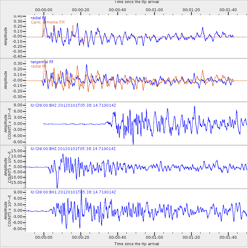
Signal To Noise
| Channel | StoN | STA | LTA |
| IU:GNI:00:BHZ:20120101T05:38:14.719014Z | 15.25764 | 1.8958921E-6 | 1.2425855E-7 |
| IU:GNI:00:BH1:20120101T05:38:14.719014Z | 4.726896 | 4.457049E-7 | 9.4291245E-8 |
| IU:GNI:00:BH2:20120101T05:38:14.719014Z | 4.545552 | 4.4045427E-7 | 9.689787E-8 |
| Arrivals |
| Ps | 5.8 SECOND |
| PpPs | 18 SECOND |
| PsPs/PpSs | 24 SECOND |


