You are here: Home > Network List > IU - Global Seismograph Network (GSN - IRIS/USGS) Stations List
> Station HNR Honiara, Solomon Islands > Earthquake Result Viewer
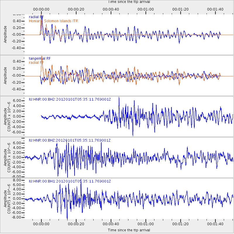
HNR Honiara, Solomon Islands - Earthquake Result Viewer
*The percent match for this event was below the threshold and hence no stack was calculated.
| Earthquake location: |
Southeast Of Honshu, Japan |
| Earthquake latitude/longitude: |
31.5/138.1 |
| Earthquake time(UTC): |
2012/01/01 (001) 05:27:55 GMT |
| Earthquake Depth: |
365 km |
| Earthquake Magnitude: |
6.2 MB, 6.8 MW, 6.8 MW |
| Earthquake Catalog/Contributor: |
WHDF/NEIC |
|
| Network: |
IU Global Seismograph Network (GSN - IRIS/USGS) |
| Station: |
HNR Honiara, Solomon Islands |
| Lat/Lon: |
9.44 S/159.95 E |
| Elevation: |
100 m |
|
| Distance: |
45.7 deg |
| Az: |
149.119 deg |
| Baz: |
333.604 deg |
| Ray Param: |
$rayparam |
*The percent match for this event was below the threshold and hence was not used in the summary stack. |
|
| Radial Match: |
64.02752 % |
| Radial Bump: |
400 |
| Transverse Match: |
62.769577 % |
| Transverse Bump: |
400 |
| SOD ConfigId: |
558545 |
| Insert Time: |
2013-09-19 09:16:18.960 +0000 |
| GWidth: |
2.5 |
| Max Bumps: |
400 |
| Tol: |
0.001 |
|
Signal To Noise
| Channel | StoN | STA | LTA |
| IU:HNR:00:BHZ:20120101T05:35:11.769001Z | 3.8547173 | 1.440003E-6 | 3.73569E-7 |
| IU:HNR:00:BH1:20120101T05:35:11.769001Z | 2.2524564 | 7.9434267E-7 | 3.5265617E-7 |
| IU:HNR:00:BH2:20120101T05:35:11.769001Z | 1.3054764 | 4.6470825E-7 | 3.5596835E-7 |
| Arrivals |
| Ps | |
| PpPs | |
| PsPs/PpSs | |


