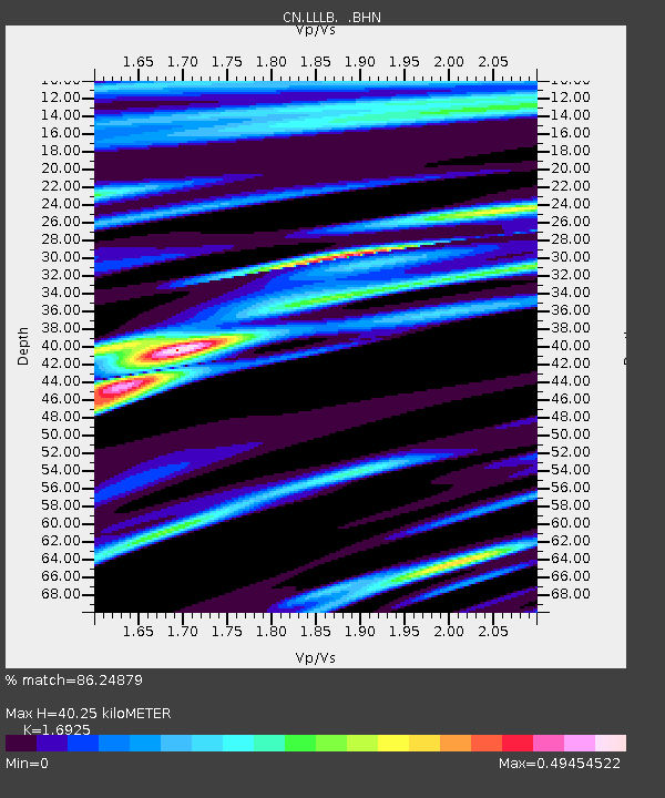
LLLB LILLOOET, BC, CANADA ADA - Earthquake Result Viewer
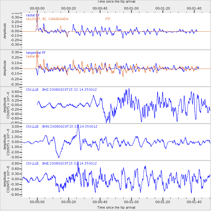
Earthquake location: Kermadec Islands, New Zealand
Earthquake latitude/longitude: -29.8/-177.7
Earthquake time(UTC): 2008/09/29 (273) 15:19:31 GMT
Earthquake Depth: 36 km
Earthquake Magnitude: 6.5 MB, 6.7 MS, 7.0 MW, 7.0 MW
Earthquake Catalog/Contributor: WHDF/NEIC
Network: CN Canadian National Seismograph Network
Station: LLLB LILLOOET, BC, CANADA ADA
Lat/Lon: 50.61 N/121.88 W
Elevation: 700 m
Distance: 94.0 deg
Az: 31.887 deg
Baz: 226.133 deg
Ray Param: 0.041138615
Estimated Moho Depth: 40.25 km
Estimated Crust Vp/Vs: 1.69
Assumed Crust Vp: 6.597 km/s
Estimated Crust Vs: 3.898 km/s
Estimated Crust Poisson's Ratio: 0.23
Radial Match: 86.24879 %
Radial Bump: 400
Transverse Match: 73.13764 %
Transverse Bump: 400
SOD ConfigId: 2560
Insert Time: 2010-02-27 06:38:40.040 +0000
GWidth: 2.5
Max Bumps: 400
Tol: 0.001

Signal To Noise

ChannelStoNSTALTA
CN:LLLB: :BHN:20080929T15:32:14.35001Z5.7400593.9465635E-76.875476E-8
CN:LLLB: :BHE:20080929T15:32:14.35001Z1.6097951.3425738E-78.34003E-8
CN:LLLB: :BHZ:20080929T15:32:14.35001Z1.09954827.7696185E-87.066192E-8
Arrivals
Ps4.3 SECOND
PpPs16 SECOND
PsPs/PpSs20 SECOND