You are here: Home > Network List > IU - Global Seismograph Network (GSN - IRIS/USGS) Stations List
> Station POHA Pohakuloa, Hawaii, USA > Earthquake Result Viewer
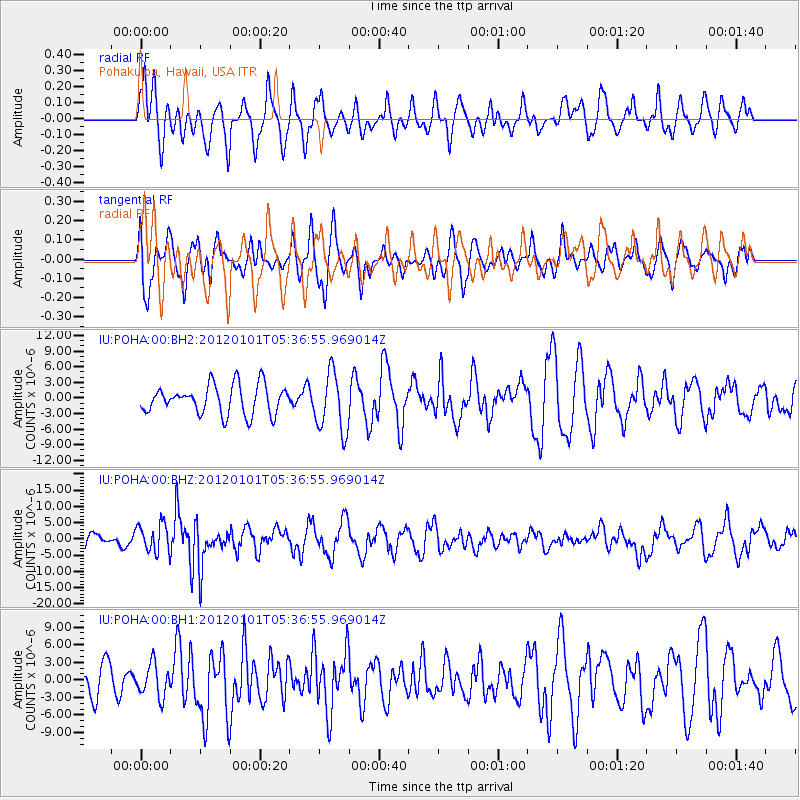
POHA Pohakuloa, Hawaii, USA - Earthquake Result Viewer
*The percent match for this event was below the threshold and hence no stack was calculated.
| Earthquake location: |
Southeast Of Honshu, Japan |
| Earthquake latitude/longitude: |
31.5/138.1 |
| Earthquake time(UTC): |
2012/01/01 (001) 05:27:55 GMT |
| Earthquake Depth: |
365 km |
| Earthquake Magnitude: |
6.2 MB, 6.8 MW, 6.8 MW |
| Earthquake Catalog/Contributor: |
WHDF/NEIC |
|
| Network: |
IU Global Seismograph Network (GSN - IRIS/USGS) |
| Station: |
POHA Pohakuloa, Hawaii, USA |
| Lat/Lon: |
19.76 N/155.53 W |
| Elevation: |
1990 m |
|
| Distance: |
60.2 deg |
| Az: |
83.96 deg |
| Baz: |
295.535 deg |
| Ray Param: |
$rayparam |
*The percent match for this event was below the threshold and hence was not used in the summary stack. |
|
| Radial Match: |
67.945244 % |
| Radial Bump: |
388 |
| Transverse Match: |
46.53812 % |
| Transverse Bump: |
333 |
| SOD ConfigId: |
558545 |
| Insert Time: |
2013-09-19 09:16:43.689 +0000 |
| GWidth: |
2.5 |
| Max Bumps: |
400 |
| Tol: |
0.001 |
|
Signal To Noise
| Channel | StoN | STA | LTA |
| IU:POHA:00:BHZ:20120101T05:36:55.969014Z | 2.5137448 | 4.3463833E-6 | 1.7290472E-6 |
| IU:POHA:00:BH1:20120101T05:36:55.969014Z | 0.92976266 | 2.7659958E-6 | 2.9749483E-6 |
| IU:POHA:00:BH2:20120101T05:36:55.969014Z | 2.0449433 | 5.7175057E-6 | 2.7959238E-6 |
| Arrivals |
| Ps | |
| PpPs | |
| PsPs/PpSs | |


