You are here: Home > Network List > US - United States National Seismic Network Stations List
> Station AMTX Amarillo, Texas, USA > Earthquake Result Viewer
AMTX Amarillo, Texas, USA - Earthquake Result Viewer
*The percent match for this event was below the threshold and hence no stack was calculated.
| Earthquake location: |
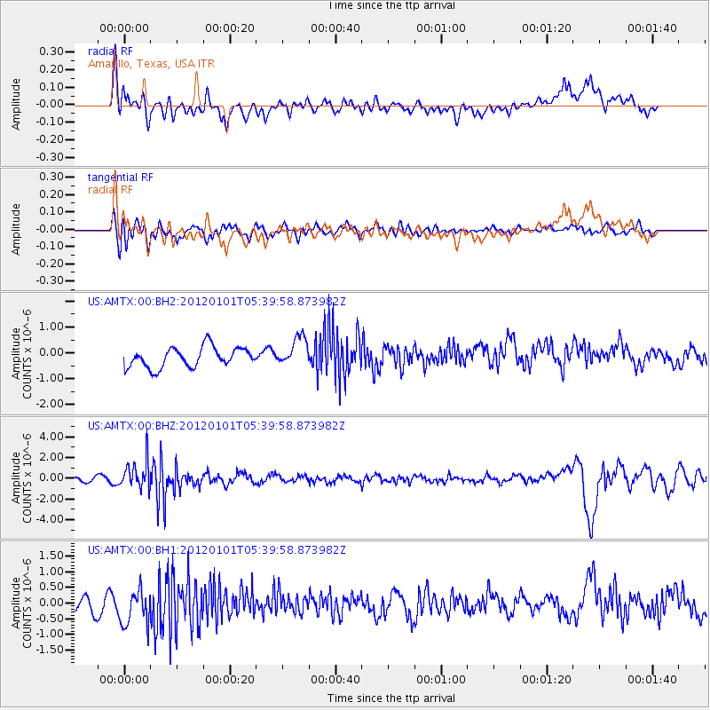
Southeast Of Honshu, Japan |
| Earthquake latitude/longitude: |
31.5/138.1 |
| Earthquake time(UTC): |
2012/01/01 (001) 05:27:55 GMT |
| Earthquake Depth: |
365 km |
| Earthquake Magnitude: |
6.2 MB, 6.8 MW, 6.8 MW |
| Earthquake Catalog/Contributor: |
WHDF/NEIC |
|
| Network: |
US United States National Seismic Network |
| Station: |
AMTX Amarillo, Texas, USA |
| Lat/Lon: |
34.53 N/101.41 W |
| Elevation: |
1010 m |
|
| Distance: |
93.7 deg |
| Az: |
45.458 deg |
| Baz: |
312.458 deg |
| Ray Param: |
$rayparam |
*The percent match for this event was below the threshold and hence was not used in the summary stack. |
|
| Radial Match: |
56.49803 % |
| Radial Bump: |
400 |
| Transverse Match: |
56.011494 % |
| Transverse Bump: |
400 |
| SOD ConfigId: |
558545 |
| Insert Time: |
2013-09-19 09:17:04.894 +0000 |
| GWidth: |
2.5 |
| Max Bumps: |
400 |
| Tol: |
0.001 |
|
Signal To Noise
| Channel | StoN | STA | LTA |
| US:AMTX:00:BHZ:20120101T05:39:58.873982Z | 8.028612 | 1.3237352E-6 | 1.6487722E-7 |
| US:AMTX:00:BH1:20120101T05:39:58.873982Z | 2.3434186 | 6.3073156E-7 | 2.6915018E-7 |
| US:AMTX:00:BH2:20120101T05:39:58.873982Z | 1.7000782 | 6.229925E-7 | 3.664493E-7 |
| Arrivals |
| Ps | |
| PpPs | |
| PsPs/PpSs | |


