You are here: Home > Network List > US - United States National Seismic Network Stations List
> Station NEW Newport, Washington, USA > Earthquake Result Viewer
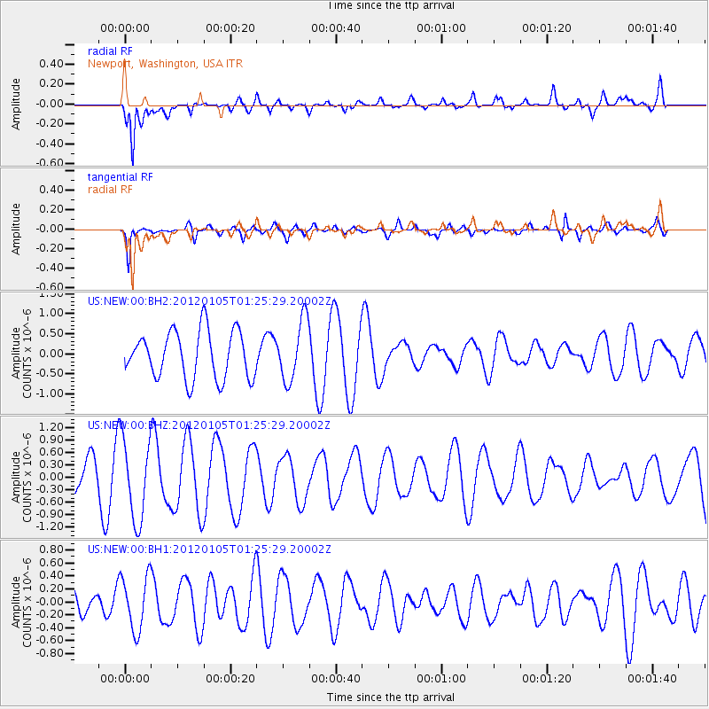
NEW Newport, Washington, USA - Earthquake Result Viewer
*The percent match for this event was below the threshold and hence no stack was calculated.
| Earthquake location: |
Tonga Islands |
| Earthquake latitude/longitude: |
-17.7/-173.5 |
| Earthquake time(UTC): |
2012/01/05 (005) 01:13:40 GMT |
| Earthquake Depth: |
35 km |
| Earthquake Magnitude: |
5.6 MW |
| Earthquake Catalog/Contributor: |
NEIC PDE/NEIC PDE-M |
|
| Network: |
US United States National Seismic Network |
| Station: |
NEW Newport, Washington, USA |
| Lat/Lon: |
48.26 N/117.12 W |
| Elevation: |
760 m |
|
| Distance: |
82.7 deg |
| Az: |
34.145 deg |
| Baz: |
233.204 deg |
| Ray Param: |
$rayparam |
*The percent match for this event was below the threshold and hence was not used in the summary stack. |
|
| Radial Match: |
72.77377 % |
| Radial Bump: |
390 |
| Transverse Match: |
80.494545 % |
| Transverse Bump: |
388 |
| SOD ConfigId: |
558545 |
| Insert Time: |
2013-09-19 09:22:21.883 +0000 |
| GWidth: |
2.5 |
| Max Bumps: |
400 |
| Tol: |
0.001 |
|
Signal To Noise
| Channel | StoN | STA | LTA |
| US:NEW:00:BHZ:20120105T01:25:29.20002Z | 1.7586627 | 9.755732E-7 | 5.5472447E-7 |
| US:NEW:00:BH1:20120105T01:25:29.20002Z | 2.113844 | 4.2209996E-7 | 1.996836E-7 |
| US:NEW:00:BH2:20120105T01:25:29.20002Z | 1.3000854 | 7.6394497E-7 | 5.876114E-7 |
| Arrivals |
| Ps | |
| PpPs | |
| PsPs/PpSs | |


