You are here: Home > Network List > II - Global Seismograph Network (GSN - IRIS/IDA) Stations List
> Station WRAB Tennant Creek, NT, Australia > Earthquake Result Viewer
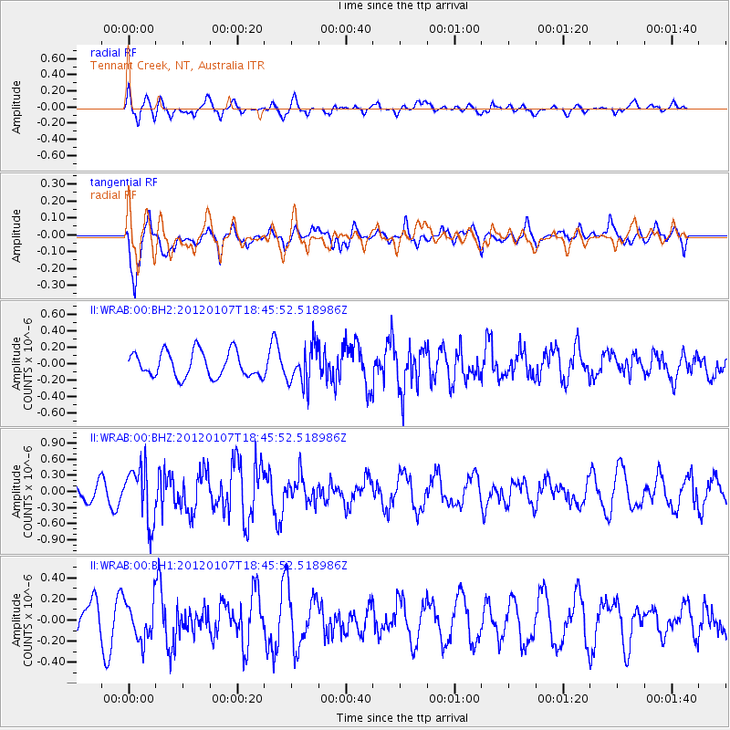
WRAB Tennant Creek, NT, Australia - Earthquake Result Viewer
*The percent match for this event was below the threshold and hence no stack was calculated.
| Earthquake location: |
Kermadec Islands Region |
| Earthquake latitude/longitude: |
-28.6/-176.9 |
| Earthquake time(UTC): |
2012/01/07 (007) 18:38:08 GMT |
| Earthquake Depth: |
10 km |
| Earthquake Magnitude: |
5.6 MW, 5.7 MW, 5.7 MB |
| Earthquake Catalog/Contributor: |
NEIC PDE/NEIC PDE-M |
|
| Network: |
II Global Seismograph Network (GSN - IRIS/IDA) |
| Station: |
WRAB Tennant Creek, NT, Australia |
| Lat/Lon: |
19.93 S/134.36 E |
| Elevation: |
366 m |
|
| Distance: |
45.0 deg |
| Az: |
269.823 deg |
| Baz: |
110.849 deg |
| Ray Param: |
$rayparam |
*The percent match for this event was below the threshold and hence was not used in the summary stack. |
|
| Radial Match: |
65.88228 % |
| Radial Bump: |
400 |
| Transverse Match: |
82.860374 % |
| Transverse Bump: |
400 |
| SOD ConfigId: |
558545 |
| Insert Time: |
2013-09-19 09:31:36.560 +0000 |
| GWidth: |
2.5 |
| Max Bumps: |
400 |
| Tol: |
0.001 |
|
Signal To Noise
| Channel | StoN | STA | LTA |
| II:WRAB:00:BHZ:20120107T18:45:52.518986Z | 3.4261851 | 5.1715904E-7 | 1.5094311E-7 |
| II:WRAB:00:BH1:20120107T18:45:52.518986Z | 1.0404154 | 1.8474334E-7 | 1.7756689E-7 |
| II:WRAB:00:BH2:20120107T18:45:52.518986Z | 1.5191575 | 2.3373198E-7 | 1.538563E-7 |
| Arrivals |
| Ps | |
| PpPs | |
| PsPs/PpSs | |


