You are here: Home > Network List > II - Global Seismograph Network (GSN - IRIS/IDA) Stations List
> Station PALK Pallekele, Sri Lanka > Earthquake Result Viewer
PALK Pallekele, Sri Lanka - Earthquake Result Viewer
| Earthquake location: |
Santa Cruz Islands |
| Earthquake latitude/longitude: |
-10.6/165.2 |
| Earthquake time(UTC): |
2012/01/09 (009) 04:07:14 GMT |
| Earthquake Depth: |
28 km |
| Earthquake Magnitude: |
6.6 MB, 6.4 MS, 6.4 MW, 6.4 MW |
| Earthquake Catalog/Contributor: |
WHDF/NEIC |
|
| Network: |
II Global Seismograph Network (GSN - IRIS/IDA) |
| Station: |
PALK Pallekele, Sri Lanka |
| Lat/Lon: |
7.27 N/80.70 E |
| Elevation: |
460 m |
|
| Distance: |
85.9 deg |
| Az: |
278.137 deg |
| Baz: |
101.188 deg |
| Ray Param: |
0.044387896 |
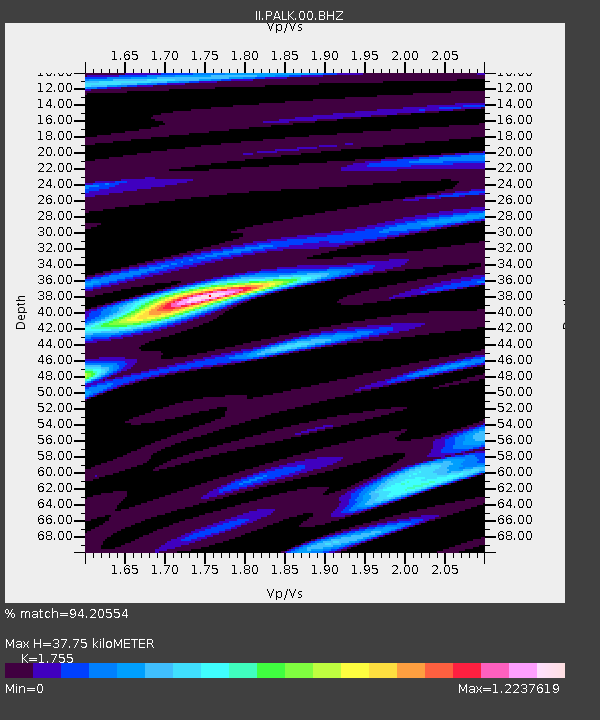
| Estimated Moho Depth: |
37.75 km |
| Estimated Crust Vp/Vs: |
1.75 |
| Assumed Crust Vp: |
6.545 km/s |
| Estimated Crust Vs: |
3.73 km/s |
| Estimated Crust Poisson's Ratio: |
0.26 |
|
| Radial Match: |
94.20554 % |
| Radial Bump: |
400 |
| Transverse Match: |
85.0187 % |
| Transverse Bump: |
400 |
| SOD ConfigId: |
558545 |
| Insert Time: |
2013-09-19 09:34:24.296 +0000 |
| GWidth: |
2.5 |
| Max Bumps: |
400 |
| Tol: |
0.001 |
|
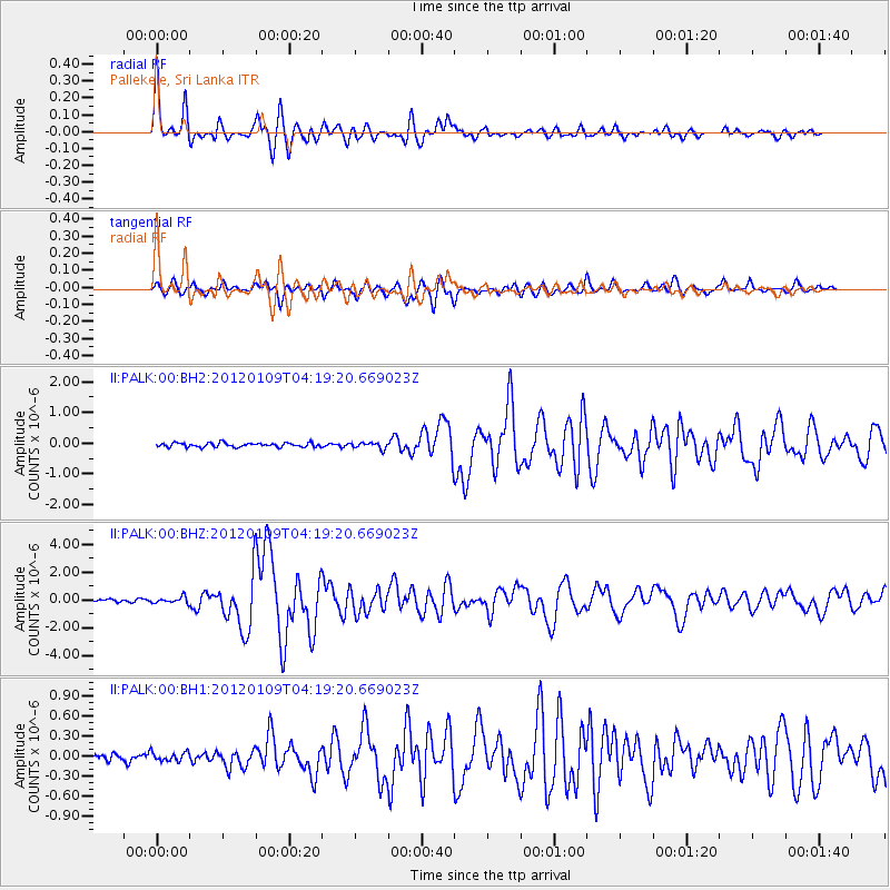
Signal To Noise
| Channel | StoN | STA | LTA |
| II:PALK:00:BHZ:20120109T04:19:20.669023Z | 3.3476114 | 2.3966254E-7 | 7.1592105E-8 |
| II:PALK:00:BH1:20120109T04:19:20.669023Z | 1.0169809 | 6.663665E-8 | 6.552399E-8 |
| II:PALK:00:BH2:20120109T04:19:20.669023Z | 1.4934225 | 9.8898894E-8 | 6.622298E-8 |
| Arrivals |
| Ps | 4.5 SECOND |
| PpPs | 16 SECOND |
| PsPs/PpSs | 20 SECOND |


