You are here: Home > Network List > CN - Canadian National Seismograph Network Stations List
> Station LLLB LILLOOET, BC, CANADA ADA > Earthquake Result Viewer
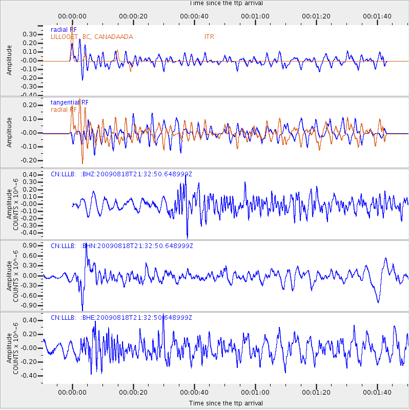
LLLB LILLOOET, BC, CANADA ADA - Earthquake Result Viewer
*The percent match for this event was below the threshold and hence no stack was calculated.
| Earthquake location: |
South Of Fiji Islands |
| Earthquake latitude/longitude: |
-26.1/-178.4 |
| Earthquake time(UTC): |
2009/08/18 (230) 21:20:47 GMT |
| Earthquake Depth: |
270 km |
| Earthquake Magnitude: |
5.5 MB, 6.3 MW, 6.3 MW |
| Earthquake Catalog/Contributor: |
WHDF/NEIC |
|
| Network: |
CN Canadian National Seismograph Network |
| Station: |
LLLB LILLOOET, BC, CANADA ADA |
| Lat/Lon: |
50.61 N/121.88 W |
| Elevation: |
700 m |
|
| Distance: |
91.2 deg |
| Az: |
32.106 deg |
| Baz: |
228.616 deg |
| Ray Param: |
$rayparam |
*The percent match for this event was below the threshold and hence was not used in the summary stack. |
|
| Radial Match: |
56.04338 % |
| Radial Bump: |
400 |
| Transverse Match: |
57.235966 % |
| Transverse Bump: |
400 |
| SOD ConfigId: |
2622 |
| Insert Time: |
2010-02-27 06:39:07.280 +0000 |
| GWidth: |
2.5 |
| Max Bumps: |
400 |
| Tol: |
0.001 |
|
Signal To Noise
| Channel | StoN | STA | LTA |
| CN:LLLB: :BHN:20090818T21:32:50.648999Z | 6.2497387 | 4.2544494E-7 | 6.807404E-8 |
| CN:LLLB: :BHE:20090818T21:32:50.648999Z | 1.204144 | 1.03593386E-7 | 8.6030724E-8 |
| CN:LLLB: :BHZ:20090818T21:32:50.648999Z | 1.4465667 | 1.05117294E-7 | 7.266675E-8 |
| Arrivals |
| Ps | |
| PpPs | |
| PsPs/PpSs | |


