You are here: Home > Network List > US - United States National Seismic Network Stations List
> Station BOZ Bozeman, Montana, USA > Earthquake Result Viewer
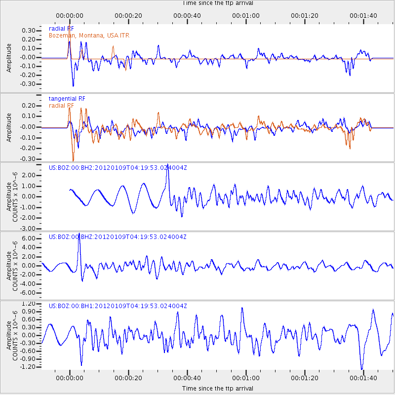
BOZ Bozeman, Montana, USA - Earthquake Result Viewer
*The percent match for this event was below the threshold and hence no stack was calculated.
| Earthquake location: |
Santa Cruz Islands |
| Earthquake latitude/longitude: |
-10.6/165.2 |
| Earthquake time(UTC): |
2012/01/09 (009) 04:07:14 GMT |
| Earthquake Depth: |
28 km |
| Earthquake Magnitude: |
6.6 MB, 6.4 MS, 6.4 MW, 6.4 MW |
| Earthquake Catalog/Contributor: |
WHDF/NEIC |
|
| Network: |
US United States National Seismic Network |
| Station: |
BOZ Bozeman, Montana, USA |
| Lat/Lon: |
45.65 N/111.63 W |
| Elevation: |
1589 m |
|
| Distance: |
92.8 deg |
| Az: |
44.218 deg |
| Baz: |
257.79 deg |
| Ray Param: |
$rayparam |
*The percent match for this event was below the threshold and hence was not used in the summary stack. |
|
| Radial Match: |
65.92516 % |
| Radial Bump: |
388 |
| Transverse Match: |
85.62707 % |
| Transverse Bump: |
400 |
| SOD ConfigId: |
558545 |
| Insert Time: |
2013-09-19 09:35:26.579 +0000 |
| GWidth: |
2.5 |
| Max Bumps: |
400 |
| Tol: |
0.001 |
|
Signal To Noise
| Channel | StoN | STA | LTA |
| US:BOZ:00:BHZ:20120109T04:19:53.024004Z | 5.268992 | 2.5852548E-6 | 4.9065454E-7 |
| US:BOZ:00:BH1:20120109T04:19:53.024004Z | 1.0031962 | 4.0621322E-7 | 4.04919E-7 |
| US:BOZ:00:BH2:20120109T04:19:53.024004Z | 1.8464042 | 1.241713E-6 | 6.7250335E-7 |
| Arrivals |
| Ps | |
| PpPs | |
| PsPs/PpSs | |


