You are here: Home > Network List > US - United States National Seismic Network Stations List
> Station DGMT Dagmar, Montana, USA > Earthquake Result Viewer
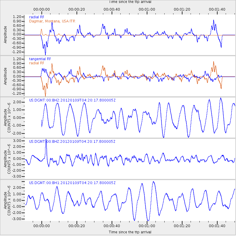
DGMT Dagmar, Montana, USA - Earthquake Result Viewer
*The percent match for this event was below the threshold and hence no stack was calculated.
| Earthquake location: |
Santa Cruz Islands |
| Earthquake latitude/longitude: |
-10.6/165.2 |
| Earthquake time(UTC): |
2012/01/09 (009) 04:07:14 GMT |
| Earthquake Depth: |
28 km |
| Earthquake Magnitude: |
6.6 MB, 6.4 MS, 6.4 MW, 6.4 MW |
| Earthquake Catalog/Contributor: |
WHDF/NEIC |
|
| Network: |
US United States National Seismic Network |
| Station: |
DGMT Dagmar, Montana, USA |
| Lat/Lon: |
48.47 N/104.20 W |
| Elevation: |
0.0 m |
|
| Distance: |
98.3 deg |
| Az: |
42.258 deg |
| Baz: |
263.41 deg |
| Ray Param: |
$rayparam |
*The percent match for this event was below the threshold and hence was not used in the summary stack. |
|
| Radial Match: |
64.62885 % |
| Radial Bump: |
400 |
| Transverse Match: |
49.71851 % |
| Transverse Bump: |
297 |
| SOD ConfigId: |
558545 |
| Insert Time: |
2013-09-19 09:35:30.620 +0000 |
| GWidth: |
2.5 |
| Max Bumps: |
400 |
| Tol: |
0.001 |
|
Signal To Noise
| Channel | StoN | STA | LTA |
| US:DGMT:00:BHZ:20120109T04:20:17.800005Z | 2.8511362 | 1.1306122E-6 | 3.9654793E-7 |
| US:DGMT:00:BH1:20120109T04:20:17.800005Z | 0.83993834 | 6.8920235E-7 | 8.2053924E-7 |
| US:DGMT:00:BH2:20120109T04:20:17.800005Z | 0.44212273 | 5.912444E-7 | 1.3372857E-6 |
| Arrivals |
| Ps | |
| PpPs | |
| PsPs/PpSs | |


