You are here: Home > Network List > II - Global Seismograph Network (GSN - IRIS/IDA) Stations List
> Station WRAB Tennant Creek, NT, Australia > Earthquake Result Viewer
WRAB Tennant Creek, NT, Australia - Earthquake Result Viewer
| Earthquake location: |
Off W Coast Of Northern Sumatra |
| Earthquake latitude/longitude: |
2.4/93.2 |
| Earthquake time(UTC): |
2012/01/10 (010) 18:36:59 GMT |
| Earthquake Depth: |
19 km |
| Earthquake Magnitude: |
6.6 MB, 7.0 MS, 7.2 MW, 7.2 MW |
| Earthquake Catalog/Contributor: |
WHDF/NEIC |
|
| Network: |
II Global Seismograph Network (GSN - IRIS/IDA) |
| Station: |
WRAB Tennant Creek, NT, Australia |
| Lat/Lon: |
19.93 S/134.36 E |
| Elevation: |
366 m |
|
| Distance: |
46.1 deg |
| Az: |
120.761 deg |
| Baz: |
294.14 deg |
| Ray Param: |
0.07083606 |
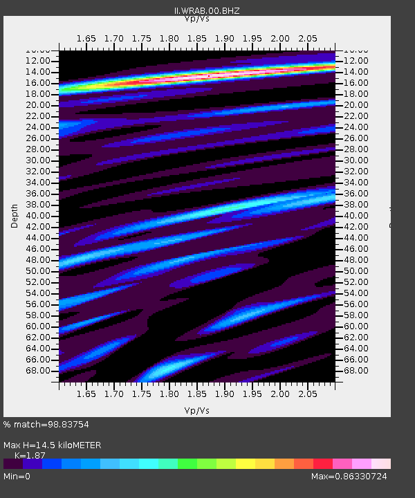
| Estimated Moho Depth: |
14.5 km |
| Estimated Crust Vp/Vs: |
1.87 |
| Assumed Crust Vp: |
6.642 km/s |
| Estimated Crust Vs: |
3.552 km/s |
| Estimated Crust Poisson's Ratio: |
0.30 |
|
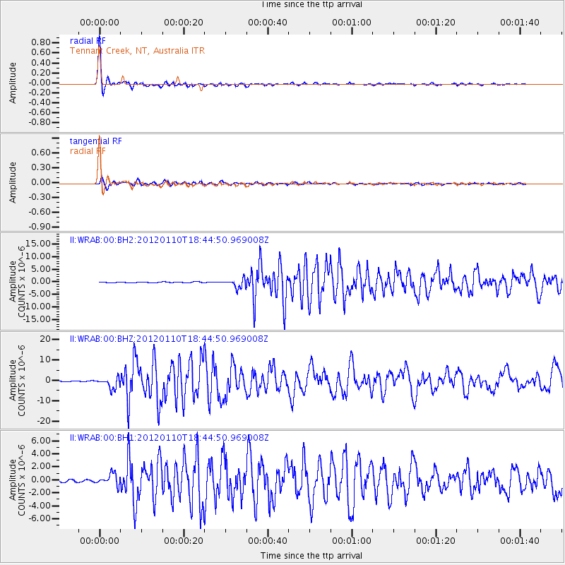
| Radial Match: |
98.83754 % |
| Radial Bump: |
261 |
| Transverse Match: |
91.19426 % |
| Transverse Bump: |
400 |
| SOD ConfigId: |
558545 |
| Insert Time: |
2013-09-19 09:37:07.799 +0000 |
| GWidth: |
2.5 |
| Max Bumps: |
400 |
| Tol: |
0.001 |
|
Signal To Noise
| Channel | StoN | STA | LTA |
| II:WRAB:00:BHZ:20120110T18:44:50.969008Z | 16.747162 | 2.667708E-6 | 1.5929315E-7 |
| II:WRAB:00:BH1:20120110T18:44:50.969008Z | 4.9993906 | 8.793636E-7 | 1.7589416E-7 |
| II:WRAB:00:BH2:20120110T18:44:50.969008Z | 9.965293 | 1.7669742E-6 | 1.7731281E-7 |
| Arrivals |
| Ps | 2.0 SECOND |
| PpPs | 5.9 SECOND |
| PsPs/PpSs | 7.9 SECOND |


