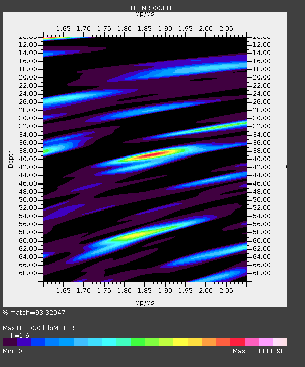
HNR Honiara, Solomon Islands - Earthquake Result Viewer
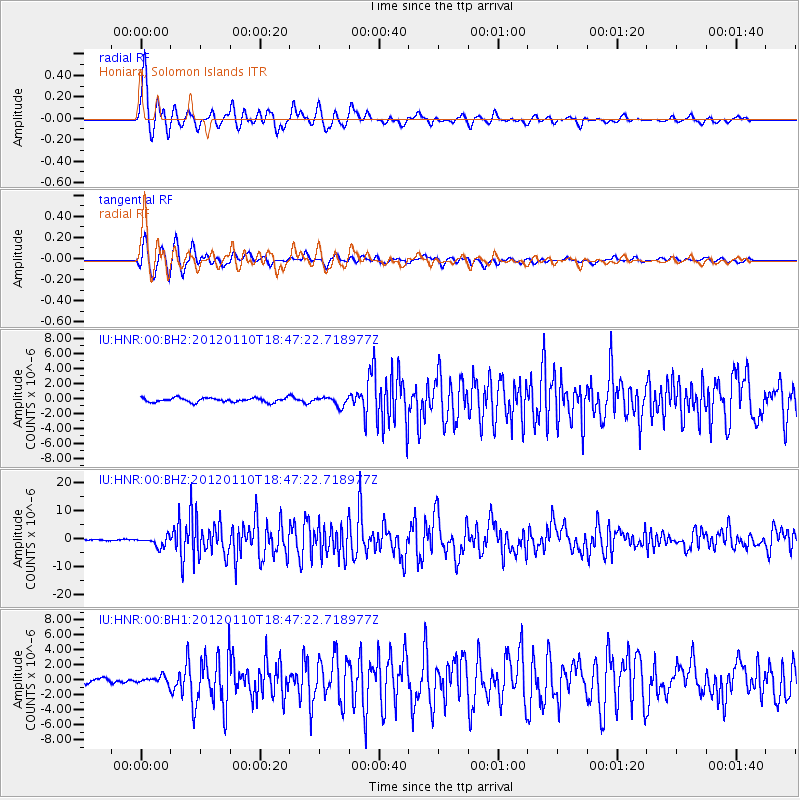
Earthquake location: Off W Coast Of Northern Sumatra
Earthquake latitude/longitude: 2.4/93.2
Earthquake time(UTC): 2012/01/10 (010) 18:36:59 GMT
Earthquake Depth: 19 km
Earthquake Magnitude: 6.6 MB, 7.0 MS, 7.2 MW, 7.2 MW
Earthquake Catalog/Contributor: WHDF/NEIC
Network: IU Global Seismograph Network (GSN - IRIS/USGS)
Station: HNR Honiara, Solomon Islands
Lat/Lon: 9.44 S/159.95 E
Elevation: 100 m
Distance: 67.5 deg
Az: 101.184 deg
Baz: 276.581 deg
Ray Param: 0.056888077
Estimated Moho Depth: 10.0 km
Estimated Crust Vp/Vs: 1.60
Assumed Crust Vp: 6.183 km/s
Estimated Crust Vs: 3.864 km/s
Estimated Crust Poisson's Ratio: 0.18
Radial Match: 93.32047 %
Radial Bump: 400
Transverse Match: 93.28402 %
Transverse Bump: 400
SOD ConfigId: 558545
Insert Time: 2013-09-19 09:37:22.374 +0000
GWidth: 2.5
Max Bumps: 400
Tol: 0.001

Signal To Noise

ChannelStoNSTALTA
IU:HNR:00:BHZ:20120110T18:47:22.718977Z6.9398511.8192776E-62.621494E-7
IU:HNR:00:BH1:20120110T18:47:22.718977Z1.47004284.7469717E-73.2291382E-7
IU:HNR:00:BH2:20120110T18:47:22.718977Z2.12222866.006107E-72.8300943E-7
Arrivals
Ps1.0 SECOND
PpPs4.0 SECOND
PsPs/PpSs5.0 SECOND