You are here: Home > Network List > IU - Global Seismograph Network (GSN - IRIS/USGS) Stations List
> Station KMBO Kilima Mbogo, Kenya > Earthquake Result Viewer
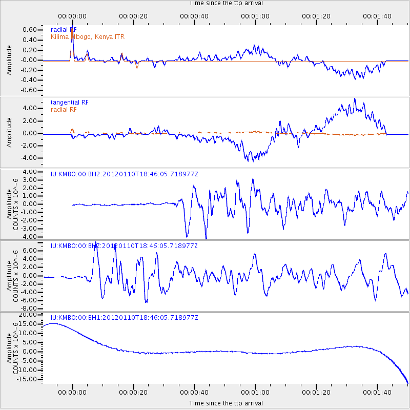
KMBO Kilima Mbogo, Kenya - Earthquake Result Viewer
*The percent match for this event was below the threshold and hence no stack was calculated.
| Earthquake location: |
Off W Coast Of Northern Sumatra |
| Earthquake latitude/longitude: |
2.4/93.2 |
| Earthquake time(UTC): |
2012/01/10 (010) 18:36:59 GMT |
| Earthquake Depth: |
19 km |
| Earthquake Magnitude: |
6.6 MB, 7.0 MS, 7.2 MW, 7.2 MW |
| Earthquake Catalog/Contributor: |
WHDF/NEIC |
|
| Network: |
IU Global Seismograph Network (GSN - IRIS/USGS) |
| Station: |
KMBO Kilima Mbogo, Kenya |
| Lat/Lon: |
1.13 S/37.25 E |
| Elevation: |
1950 m |
|
| Distance: |
56.1 deg |
| Az: |
267.02 deg |
| Baz: |
86.331 deg |
| Ray Param: |
$rayparam |
*The percent match for this event was below the threshold and hence was not used in the summary stack. |
|
| Radial Match: |
48.26731 % |
| Radial Bump: |
400 |
| Transverse Match: |
36.56692 % |
| Transverse Bump: |
400 |
| SOD ConfigId: |
558545 |
| Insert Time: |
2013-09-19 09:37:34.464 +0000 |
| GWidth: |
2.5 |
| Max Bumps: |
400 |
| Tol: |
0.001 |
|
Signal To Noise
| Channel | StoN | STA | LTA |
| IU:KMBO:00:BHZ:20120110T18:46:05.718977Z | 2.8515387 | 2.7488804E-7 | 9.63999E-8 |
| IU:KMBO:00:BH1:20120110T18:46:05.718977Z | 0.83983904 | 4.753451E-5 | 5.6599547E-5 |
| IU:KMBO:00:BH2:20120110T18:46:05.718977Z | 2.7258208 | 1.74135E-7 | 6.388351E-8 |
| Arrivals |
| Ps | |
| PpPs | |
| PsPs/PpSs | |


