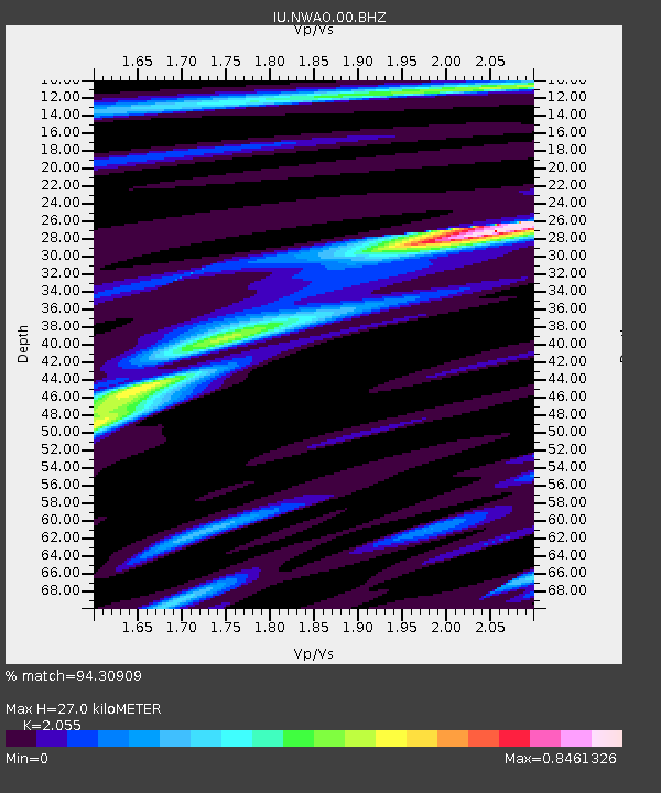
NWAO Narrogin, Australia - Earthquake Result Viewer
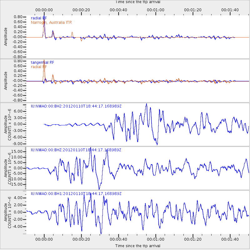
Earthquake location: Off W Coast Of Northern Sumatra
Earthquake latitude/longitude: 2.4/93.2
Earthquake time(UTC): 2012/01/10 (010) 18:36:59 GMT
Earthquake Depth: 19 km
Earthquake Magnitude: 6.6 MB, 7.0 MS, 7.2 MW, 7.2 MW
Earthquake Catalog/Contributor: WHDF/NEIC
Network: IU Global Seismograph Network (GSN - IRIS/USGS)
Station: NWAO Narrogin, Australia
Lat/Lon: 32.93 S/117.24 E
Elevation: 380 m
Distance: 41.9 deg
Az: 149.131 deg
Baz: 322.445 deg
Ray Param: 0.073491834
Estimated Moho Depth: 27.0 km
Estimated Crust Vp/Vs: 2.06
Assumed Crust Vp: 6.419 km/s
Estimated Crust Vs: 3.124 km/s
Estimated Crust Poisson's Ratio: 0.34
Radial Match: 94.30909 %
Radial Bump: 266
Transverse Match: 77.216545 %
Transverse Bump: 400
SOD ConfigId: 558545
Insert Time: 2013-09-19 09:37:48.025 +0000
GWidth: 2.5
Max Bumps: 400
Tol: 0.001

Signal To Noise

ChannelStoNSTALTA
IU:NWAO:00:BHZ:20120110T18:44:17.168989Z4.24475772.1663277E-65.103537E-7
IU:NWAO:00:BH1:20120110T18:44:17.168989Z2.27048358.757328E-73.8570323E-7
IU:NWAO:00:BH2:20120110T18:44:17.168989Z4.3943871.2501414E-62.8448596E-7
Arrivals
Ps4.7 SECOND
PpPs12 SECOND
PsPs/PpSs17 SECOND