You are here: Home > Network List > US - United States National Seismic Network Stations List
> Station AMTX Amarillo, Texas, USA > Earthquake Result Viewer
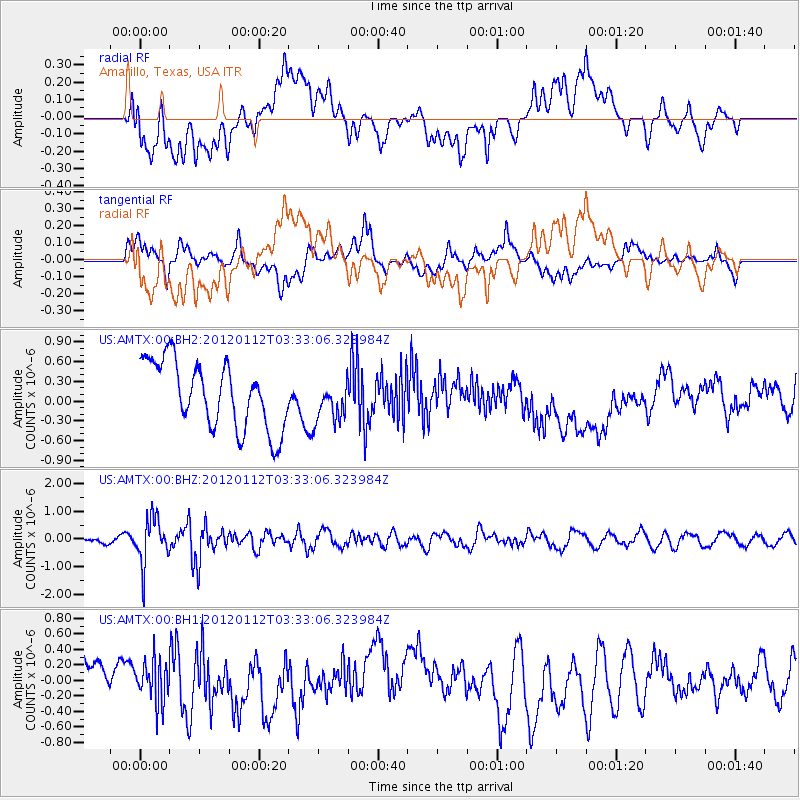
AMTX Amarillo, Texas, USA - Earthquake Result Viewer
*The percent match for this event was below the threshold and hence no stack was calculated.
| Earthquake location: |
Near East Coast Of Honshu, Japan |
| Earthquake latitude/longitude: |
37.0/141.1 |
| Earthquake time(UTC): |
2012/01/12 (012) 03:20:49 GMT |
| Earthquake Depth: |
16 km |
| Earthquake Magnitude: |
6.0 MB, 5.2 MS, 5.5 MW, 5.5 MW |
| Earthquake Catalog/Contributor: |
WHDF/NEIC |
|
| Network: |
US United States National Seismic Network |
| Station: |
AMTX Amarillo, Texas, USA |
| Lat/Lon: |
34.53 N/101.41 W |
| Elevation: |
1010 m |
|
| Distance: |
88.1 deg |
| Az: |
47.102 deg |
| Baz: |
314.731 deg |
| Ray Param: |
$rayparam |
*The percent match for this event was below the threshold and hence was not used in the summary stack. |
|
| Radial Match: |
38.887066 % |
| Radial Bump: |
400 |
| Transverse Match: |
53.969265 % |
| Transverse Bump: |
400 |
| SOD ConfigId: |
558545 |
| Insert Time: |
2013-09-19 09:40:56.409 +0000 |
| GWidth: |
2.5 |
| Max Bumps: |
400 |
| Tol: |
0.001 |
|
Signal To Noise
| Channel | StoN | STA | LTA |
| US:AMTX:00:BHZ:20120112T03:33:06.323984Z | 6.931738 | 8.402634E-7 | 1.2121973E-7 |
| US:AMTX:00:BH1:20120112T03:33:06.323984Z | 0.7761684 | 2.751583E-7 | 3.5450847E-7 |
| US:AMTX:00:BH2:20120112T03:33:06.323984Z | 0.79692423 | 3.7863344E-7 | 4.751185E-7 |
| Arrivals |
| Ps | |
| PpPs | |
| PsPs/PpSs | |


