You are here: Home > Network List > II - Global Seismograph Network (GSN - IRIS/IDA) Stations List
> Station WRAB Tennant Creek, NT, Australia > Earthquake Result Viewer
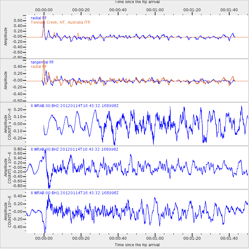
WRAB Tennant Creek, NT, Australia - Earthquake Result Viewer
*The percent match for this event was below the threshold and hence no stack was calculated.
| Earthquake location: |
Philippine Islands Region |
| Earthquake latitude/longitude: |
19.2/121.2 |
| Earthquake time(UTC): |
2012/01/14 (014) 16:36:21 GMT |
| Earthquake Depth: |
17 km |
| Earthquake Magnitude: |
5.5 MB, 5.4 MS, 5.8 MW, 5.7 MW |
| Earthquake Catalog/Contributor: |
WHDF/NEIC |
|
| Network: |
II Global Seismograph Network (GSN - IRIS/IDA) |
| Station: |
WRAB Tennant Creek, NT, Australia |
| Lat/Lon: |
19.93 S/134.36 E |
| Elevation: |
366 m |
|
| Distance: |
41.0 deg |
| Az: |
160.876 deg |
| Baz: |
340.786 deg |
| Ray Param: |
$rayparam |
*The percent match for this event was below the threshold and hence was not used in the summary stack. |
|
| Radial Match: |
71.07517 % |
| Radial Bump: |
400 |
| Transverse Match: |
72.68029 % |
| Transverse Bump: |
400 |
| SOD ConfigId: |
558545 |
| Insert Time: |
2013-09-19 09:46:24.162 +0000 |
| GWidth: |
2.5 |
| Max Bumps: |
400 |
| Tol: |
0.001 |
|
Signal To Noise
| Channel | StoN | STA | LTA |
| II:WRAB:00:BHZ:20120114T16:43:32.168998Z | 3.5372715 | 5.2628957E-7 | 1.4878404E-7 |
| II:WRAB:00:BH1:20120114T16:43:32.168998Z | 2.3377147 | 2.7998271E-7 | 1.197677E-7 |
| II:WRAB:00:BH2:20120114T16:43:32.168998Z | 1.1112363 | 9.883501E-8 | 8.894148E-8 |
| Arrivals |
| Ps | |
| PpPs | |
| PsPs/PpSs | |


