You are here: Home > Network List > IU - Global Seismograph Network (GSN - IRIS/USGS) Stations List
> Station PMG Port Moresby, New Guinea > Earthquake Result Viewer
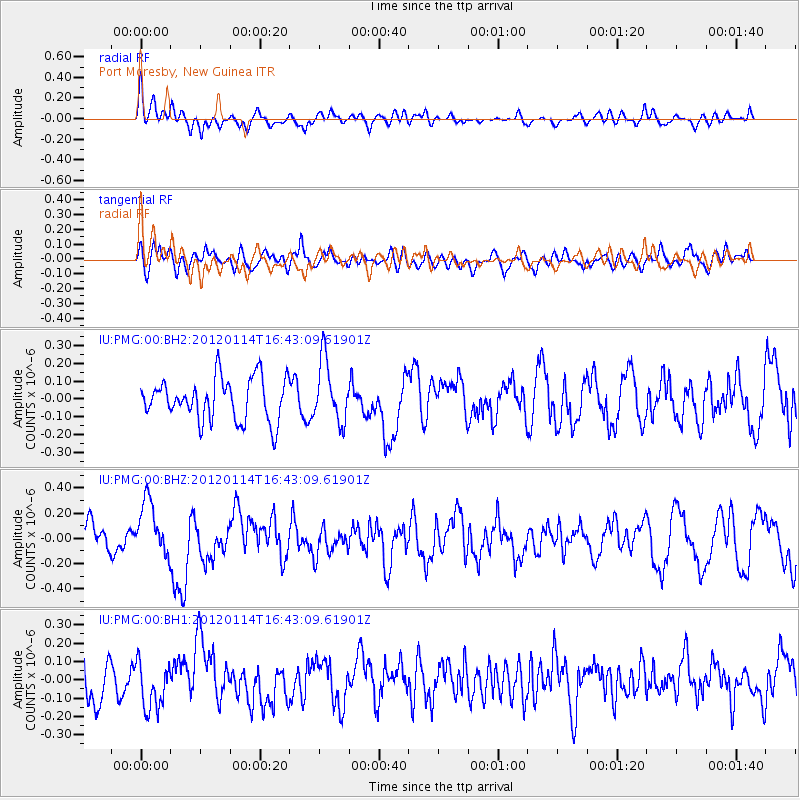
PMG Port Moresby, New Guinea - Earthquake Result Viewer
*The percent match for this event was below the threshold and hence no stack was calculated.
| Earthquake location: |
Philippine Islands Region |
| Earthquake latitude/longitude: |
19.2/121.2 |
| Earthquake time(UTC): |
2012/01/14 (014) 16:36:21 GMT |
| Earthquake Depth: |
17 km |
| Earthquake Magnitude: |
5.5 MB, 5.4 MS, 5.8 MW, 5.7 MW |
| Earthquake Catalog/Contributor: |
WHDF/NEIC |
|
| Network: |
IU Global Seismograph Network (GSN - IRIS/USGS) |
| Station: |
PMG Port Moresby, New Guinea |
| Lat/Lon: |
9.40 S/147.16 E |
| Elevation: |
90 m |
|
| Distance: |
38.3 deg |
| Az: |
135.703 deg |
| Baz: |
318.02 deg |
| Ray Param: |
$rayparam |
*The percent match for this event was below the threshold and hence was not used in the summary stack. |
|
| Radial Match: |
61.69385 % |
| Radial Bump: |
400 |
| Transverse Match: |
36.051388 % |
| Transverse Bump: |
400 |
| SOD ConfigId: |
558545 |
| Insert Time: |
2013-09-19 09:46:55.345 +0000 |
| GWidth: |
2.5 |
| Max Bumps: |
400 |
| Tol: |
0.001 |
|
Signal To Noise
| Channel | StoN | STA | LTA |
| IU:PMG:00:BHZ:20120114T16:43:09.61901Z | 2.0291302 | 2.2086888E-7 | 1.08849044E-7 |
| IU:PMG:00:BH1:20120114T16:43:09.61901Z | 1.1357067 | 1.2660036E-7 | 1.1147275E-7 |
| IU:PMG:00:BH2:20120114T16:43:09.61901Z | 1.4675138 | 1.7287306E-7 | 1.1779996E-7 |
| Arrivals |
| Ps | |
| PpPs | |
| PsPs/PpSs | |


