You are here: Home > Network List > IU - Global Seismograph Network (GSN - IRIS/USGS) Stations List
> Station HNR Honiara, Solomon Islands > Earthquake Result Viewer
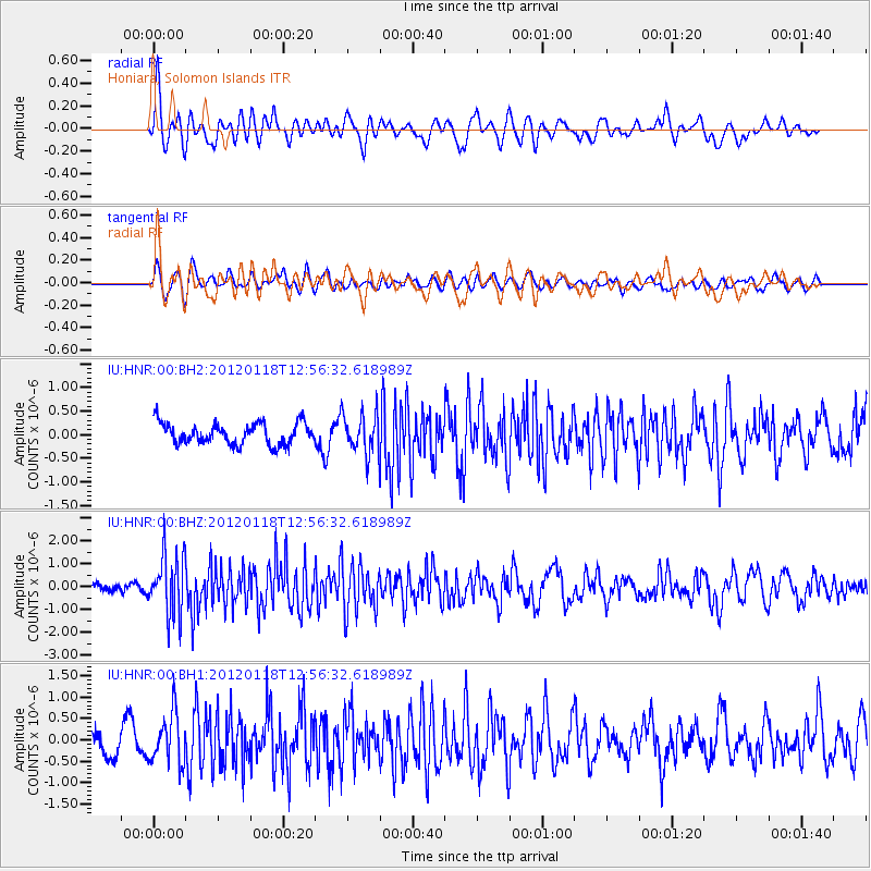
HNR Honiara, Solomon Islands - Earthquake Result Viewer
*The percent match for this event was below the threshold and hence no stack was calculated.
| Earthquake location: |
Southern Molucca Sea |
| Earthquake latitude/longitude: |
-0.9/126.8 |
| Earthquake time(UTC): |
2012/01/18 (018) 12:50:20 GMT |
| Earthquake Depth: |
19 km |
| Earthquake Magnitude: |
5.6 MB, 5.0 MS, 5.8 MW, 5.6 MW |
| Earthquake Catalog/Contributor: |
WHDF/NEIC |
|
| Network: |
IU Global Seismograph Network (GSN - IRIS/USGS) |
| Station: |
HNR Honiara, Solomon Islands |
| Lat/Lon: |
9.44 S/159.95 E |
| Elevation: |
100 m |
|
| Distance: |
34.0 deg |
| Az: |
105.583 deg |
| Baz: |
282.533 deg |
| Ray Param: |
$rayparam |
*The percent match for this event was below the threshold and hence was not used in the summary stack. |
|
| Radial Match: |
64.388275 % |
| Radial Bump: |
400 |
| Transverse Match: |
58.542065 % |
| Transverse Bump: |
400 |
| SOD ConfigId: |
558545 |
| Insert Time: |
2013-09-19 10:01:32.467 +0000 |
| GWidth: |
2.5 |
| Max Bumps: |
400 |
| Tol: |
0.001 |
|
Signal To Noise
| Channel | StoN | STA | LTA |
| IU:HNR:00:BHZ:20120118T12:56:32.618989Z | 5.1403604 | 1.3298944E-6 | 2.587162E-7 |
| IU:HNR:00:BH1:20120118T12:56:32.618989Z | 1.966767 | 5.670249E-7 | 2.8830306E-7 |
| IU:HNR:00:BH2:20120118T12:56:32.618989Z | 1.8764571 | 4.2247763E-7 | 2.2514644E-7 |
| Arrivals |
| Ps | |
| PpPs | |
| PsPs/PpSs | |


