You are here: Home > Network List > IU - Global Seismograph Network (GSN - IRIS/USGS) Stations List
> Station MAJO Matsushiro, Japan > Earthquake Result Viewer
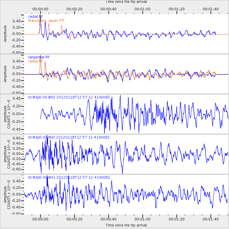
MAJO Matsushiro, Japan - Earthquake Result Viewer
*The percent match for this event was below the threshold and hence no stack was calculated.
| Earthquake location: |
Southern Molucca Sea |
| Earthquake latitude/longitude: |
-0.9/126.8 |
| Earthquake time(UTC): |
2012/01/18 (018) 12:50:20 GMT |
| Earthquake Depth: |
19 km |
| Earthquake Magnitude: |
5.6 MB, 5.0 MS, 5.8 MW, 5.6 MW |
| Earthquake Catalog/Contributor: |
WHDF/NEIC |
|
| Network: |
IU Global Seismograph Network (GSN - IRIS/USGS) |
| Station: |
MAJO Matsushiro, Japan |
| Lat/Lon: |
36.55 N/138.20 E |
| Elevation: |
405 m |
|
| Distance: |
38.7 deg |
| Az: |
14.714 deg |
| Baz: |
198.383 deg |
| Ray Param: |
$rayparam |
*The percent match for this event was below the threshold and hence was not used in the summary stack. |
|
| Radial Match: |
74.1124 % |
| Radial Bump: |
400 |
| Transverse Match: |
61.36711 % |
| Transverse Bump: |
400 |
| SOD ConfigId: |
558545 |
| Insert Time: |
2013-09-19 10:01:44.281 +0000 |
| GWidth: |
2.5 |
| Max Bumps: |
400 |
| Tol: |
0.001 |
|
Signal To Noise
| Channel | StoN | STA | LTA |
| IU:MAJO:00:BHZ:20120118T12:57:12.419008Z | 4.2323594 | 3.433916E-7 | 8.113479E-8 |
| IU:MAJO:00:BH1:20120118T12:57:12.419008Z | 2.3732476 | 1.9716546E-7 | 8.307833E-8 |
| IU:MAJO:00:BH2:20120118T12:57:12.419008Z | 2.490822 | 1.9655687E-7 | 7.891246E-8 |
| Arrivals |
| Ps | |
| PpPs | |
| PsPs/PpSs | |


