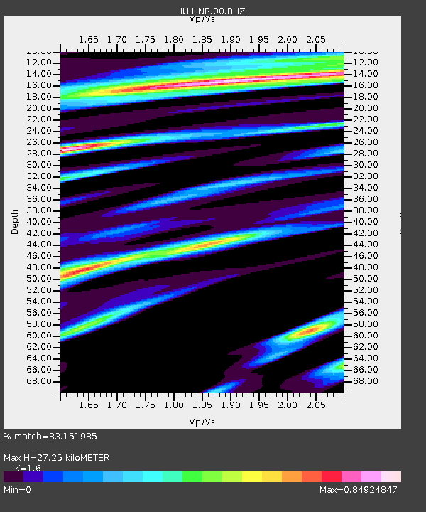
HNR Honiara, Solomon Islands - Earthquake Result Viewer
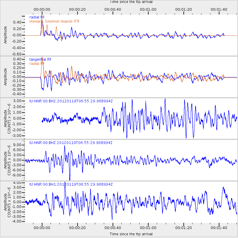
Earthquake location: Off W. Coast Of S. Island, N.Z.
Earthquake latitude/longitude: -46.7/165.8
Earthquake time(UTC): 2012/01/19 (019) 06:48:48 GMT
Earthquake Depth: 20 km
Earthquake Magnitude: 6.0 MB, 5.8 MS, 5.9 MW, 5.9 MW
Earthquake Catalog/Contributor: WHDF/NEIC
Network: IU Global Seismograph Network (GSN - IRIS/USGS)
Station: HNR Honiara, Solomon Islands
Lat/Lon: 9.44 S/159.95 E
Elevation: 100 m
Distance: 37.4 deg
Az: 350.512 deg
Baz: 173.396 deg
Ray Param: 0.07610534
Estimated Moho Depth: 27.25 km
Estimated Crust Vp/Vs: 1.60
Assumed Crust Vp: 6.183 km/s
Estimated Crust Vs: 3.864 km/s
Estimated Crust Poisson's Ratio: 0.18
Radial Match: 83.151985 %
Radial Bump: 400
Transverse Match: 80.48602 %
Transverse Bump: 400
SOD ConfigId: 558545
Insert Time: 2013-09-19 10:05:15.951 +0000
GWidth: 2.5
Max Bumps: 400
Tol: 0.001

Signal To Noise

ChannelStoNSTALTA
IU:HNR:00:BHZ:20120119T06:55:29.968994Z6.10743432.8532093E-64.6716985E-7
IU:HNR:00:BH1:20120119T06:55:29.968994Z2.85474189.561353E-73.349288E-7
IU:HNR:00:BH2:20120119T06:55:29.968994Z1.4045815.561709E-73.959693E-7
Arrivals
Ps2.9 SECOND
PpPs11 SECOND
PsPs/PpSs13 SECOND