You are here: Home > Network List > II - Global Seismograph Network (GSN - IRIS/IDA) Stations List
> Station KAPI Kappang, Sulawesi, Indonesia > Earthquake Result Viewer
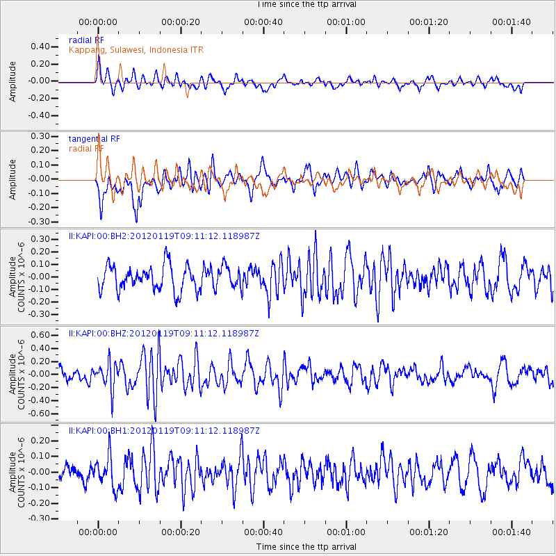
KAPI Kappang, Sulawesi, Indonesia - Earthquake Result Viewer
*The percent match for this event was below the threshold and hence no stack was calculated.
| Earthquake location: |
Off W. Coast Of S. Island, N.Z. |
| Earthquake latitude/longitude: |
-46.8/165.6 |
| Earthquake time(UTC): |
2012/01/19 (019) 09:01:55 GMT |
| Earthquake Depth: |
15 km |
| Earthquake Magnitude: |
5.5 ML |
| Earthquake Catalog/Contributor: |
NEIC PDE/NEIC PDE-M |
|
| Network: |
II Global Seismograph Network (GSN - IRIS/IDA) |
| Station: |
KAPI Kappang, Sulawesi, Indonesia |
| Lat/Lon: |
5.01 S/119.75 E |
| Elevation: |
300 m |
|
| Distance: |
57.3 deg |
| Az: |
301.858 deg |
| Baz: |
144.119 deg |
| Ray Param: |
$rayparam |
*The percent match for this event was below the threshold and hence was not used in the summary stack. |
|
| Radial Match: |
72.23681 % |
| Radial Bump: |
400 |
| Transverse Match: |
54.200047 % |
| Transverse Bump: |
400 |
| SOD ConfigId: |
558545 |
| Insert Time: |
2013-09-19 10:06:07.768 +0000 |
| GWidth: |
2.5 |
| Max Bumps: |
400 |
| Tol: |
0.001 |
|
Signal To Noise
| Channel | StoN | STA | LTA |
| II:KAPI:00:BHZ:20120119T09:11:12.118987Z | 2.4235144 | 2.0893359E-7 | 8.6210996E-8 |
| II:KAPI:00:BH1:20120119T09:11:12.118987Z | 1.3785855 | 1.0296731E-7 | 7.4690554E-8 |
| II:KAPI:00:BH2:20120119T09:11:12.118987Z | 0.8836157 | 8.768289E-8 | 9.923193E-8 |
| Arrivals |
| Ps | |
| PpPs | |
| PsPs/PpSs | |


