You are here: Home > Network List > IU - Global Seismograph Network (GSN - IRIS/USGS) Stations List
> Station HNR Honiara, Solomon Islands > Earthquake Result Viewer
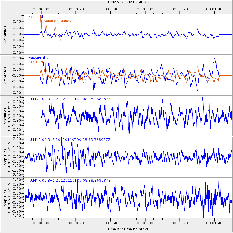
HNR Honiara, Solomon Islands - Earthquake Result Viewer
*The percent match for this event was below the threshold and hence no stack was calculated.
| Earthquake location: |
Off W. Coast Of S. Island, N.Z. |
| Earthquake latitude/longitude: |
-46.8/165.6 |
| Earthquake time(UTC): |
2012/01/19 (019) 09:01:55 GMT |
| Earthquake Depth: |
15 km |
| Earthquake Magnitude: |
5.5 ML |
| Earthquake Catalog/Contributor: |
NEIC PDE/NEIC PDE-M |
|
| Network: |
IU Global Seismograph Network (GSN - IRIS/USGS) |
| Station: |
HNR Honiara, Solomon Islands |
| Lat/Lon: |
9.44 S/159.95 E |
| Elevation: |
100 m |
|
| Distance: |
37.5 deg |
| Az: |
350.809 deg |
| Baz: |
173.61 deg |
| Ray Param: |
$rayparam |
*The percent match for this event was below the threshold and hence was not used in the summary stack. |
|
| Radial Match: |
54.440125 % |
| Radial Bump: |
400 |
| Transverse Match: |
66.12077 % |
| Transverse Bump: |
400 |
| SOD ConfigId: |
558545 |
| Insert Time: |
2013-09-19 10:06:15.625 +0000 |
| GWidth: |
2.5 |
| Max Bumps: |
400 |
| Tol: |
0.001 |
|
Signal To Noise
| Channel | StoN | STA | LTA |
| IU:HNR:00:BHZ:20120119T09:08:38.368987Z | 2.252615 | 7.265076E-7 | 3.2251745E-7 |
| IU:HNR:00:BH1:20120119T09:08:38.368987Z | 1.0084727 | 3.01073E-7 | 2.9854354E-7 |
| IU:HNR:00:BH2:20120119T09:08:38.368987Z | 1.1058714 | 3.8064906E-7 | 3.442073E-7 |
| Arrivals |
| Ps | |
| PpPs | |
| PsPs/PpSs | |


