You are here: Home > Network List > IU - Global Seismograph Network (GSN - IRIS/USGS) Stations List
> Station GNI Garni, Armenia > Earthquake Result Viewer
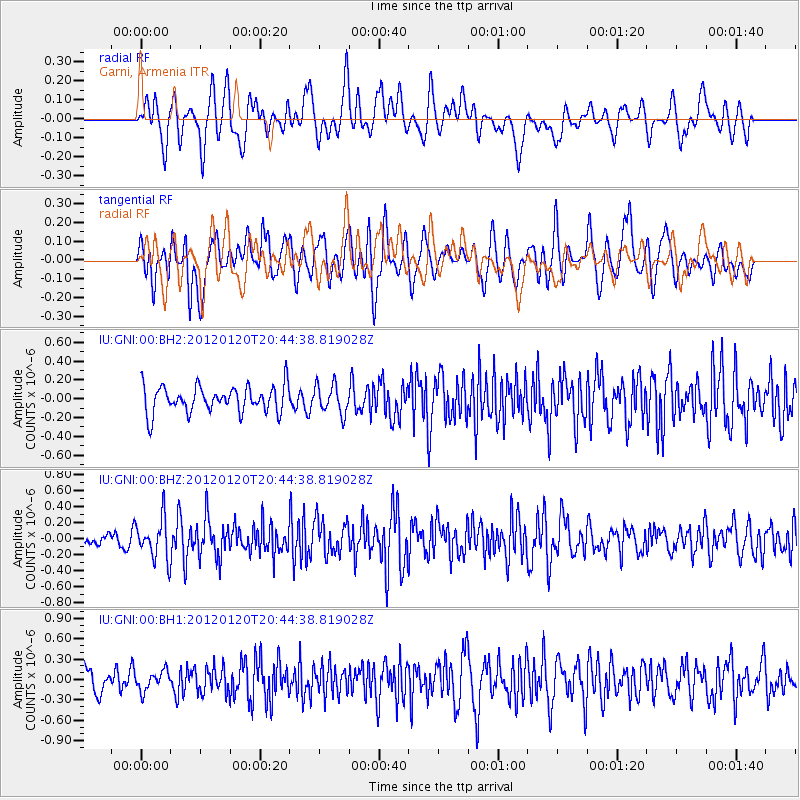
GNI Garni, Armenia - Earthquake Result Viewer
*The percent match for this event was below the threshold and hence no stack was calculated.
| Earthquake location: |
Flores Region, Indonesia |
| Earthquake latitude/longitude: |
-8.4/119.7 |
| Earthquake time(UTC): |
2012/01/20 (020) 20:32:53 GMT |
| Earthquake Depth: |
126 km |
| Earthquake Magnitude: |
5.7 MB, 5.7 MW, 5.6 MW |
| Earthquake Catalog/Contributor: |
WHDF/NEIC |
|
| Network: |
IU Global Seismograph Network (GSN - IRIS/USGS) |
| Station: |
GNI Garni, Armenia |
| Lat/Lon: |
40.15 N/44.74 E |
| Elevation: |
1609 m |
|
| Distance: |
84.1 deg |
| Az: |
311.905 deg |
| Baz: |
106.123 deg |
| Ray Param: |
$rayparam |
*The percent match for this event was below the threshold and hence was not used in the summary stack. |
|
| Radial Match: |
66.81994 % |
| Radial Bump: |
400 |
| Transverse Match: |
53.772438 % |
| Transverse Bump: |
400 |
| SOD ConfigId: |
558545 |
| Insert Time: |
2013-09-19 10:09:24.288 +0000 |
| GWidth: |
2.5 |
| Max Bumps: |
400 |
| Tol: |
0.001 |
|
Signal To Noise
| Channel | StoN | STA | LTA |
| IU:GNI:00:BHZ:20120120T20:44:38.819028Z | 2.116547 | 2.525534E-7 | 1.193233E-7 |
| IU:GNI:00:BH1:20120120T20:44:38.819028Z | 0.84910166 | 1.4115638E-7 | 1.6624203E-7 |
| IU:GNI:00:BH2:20120120T20:44:38.819028Z | 1.07976 | 1.524661E-7 | 1.412037E-7 |
| Arrivals |
| Ps | |
| PpPs | |
| PsPs/PpSs | |


