You are here: Home > Network List > US - United States National Seismic Network Stations List
> Station DUG Dugway, Tooele County, Utah, USA > Earthquake Result Viewer
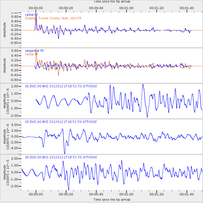
DUG Dugway, Tooele County, Utah, USA - Earthquake Result Viewer
*The percent match for this event was below the threshold and hence no stack was calculated.
| Earthquake location: |
Near Coast Of Chiapas, Mexico |
| Earthquake latitude/longitude: |
14.9/-93.0 |
| Earthquake time(UTC): |
2012/01/21 (021) 18:47:11 GMT |
| Earthquake Depth: |
45 km |
| Earthquake Magnitude: |
5.9 MB, 5.8 MS, 6.2 MW, 6.3 MW |
| Earthquake Catalog/Contributor: |
WHDF/NEIC |
|
| Network: |
US United States National Seismic Network |
| Station: |
DUG Dugway, Tooele County, Utah, USA |
| Lat/Lon: |
40.19 N/112.81 W |
| Elevation: |
1477 m |
|
| Distance: |
30.6 deg |
| Az: |
329.335 deg |
| Baz: |
139.923 deg |
| Ray Param: |
$rayparam |
*The percent match for this event was below the threshold and hence was not used in the summary stack. |
|
| Radial Match: |
77.867004 % |
| Radial Bump: |
400 |
| Transverse Match: |
73.74978 % |
| Transverse Bump: |
400 |
| SOD ConfigId: |
558545 |
| Insert Time: |
2013-09-19 10:12:33.660 +0000 |
| GWidth: |
2.5 |
| Max Bumps: |
400 |
| Tol: |
0.001 |
|
Signal To Noise
| Channel | StoN | STA | LTA |
| US:DUG:00:BHZ:20120121T18:52:50.975009Z | 2.659634 | 8.511259E-7 | 3.2001614E-7 |
| US:DUG:00:BH1:20120121T18:52:50.975009Z | 1.0244924 | 3.2001313E-7 | 3.1236263E-7 |
| US:DUG:00:BH2:20120121T18:52:50.975009Z | 0.98881793 | 4.3844886E-7 | 4.4340706E-7 |
| Arrivals |
| Ps | |
| PpPs | |
| PsPs/PpSs | |


