You are here: Home > Network List > US - United States National Seismic Network Stations List
> Station EGMT Eagleton, Montana, USA > Earthquake Result Viewer
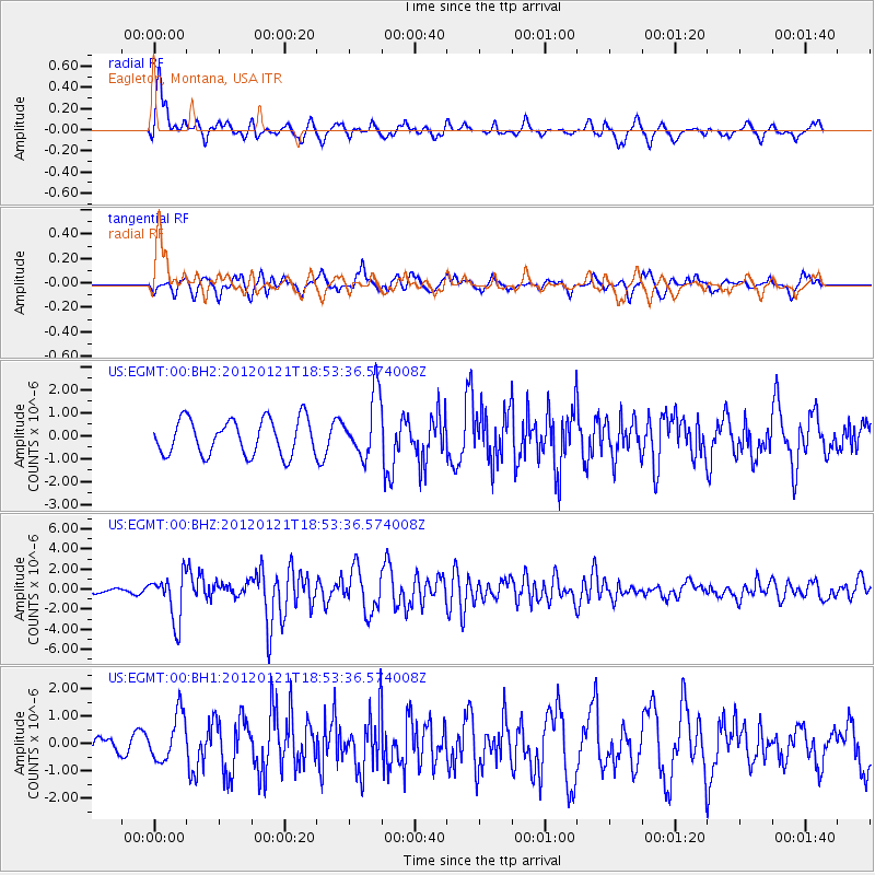
EGMT Eagleton, Montana, USA - Earthquake Result Viewer
*The percent match for this event was below the threshold and hence no stack was calculated.
| Earthquake location: |
Near Coast Of Chiapas, Mexico |
| Earthquake latitude/longitude: |
14.9/-93.0 |
| Earthquake time(UTC): |
2012/01/21 (021) 18:47:11 GMT |
| Earthquake Depth: |
45 km |
| Earthquake Magnitude: |
5.9 MB, 5.8 MS, 6.2 MW, 6.3 MW |
| Earthquake Catalog/Contributor: |
WHDF/NEIC |
|
| Network: |
US United States National Seismic Network |
| Station: |
EGMT Eagleton, Montana, USA |
| Lat/Lon: |
48.02 N/109.75 W |
| Elevation: |
1055 m |
|
| Distance: |
35.8 deg |
| Az: |
340.708 deg |
| Baz: |
151.584 deg |
| Ray Param: |
$rayparam |
*The percent match for this event was below the threshold and hence was not used in the summary stack. |
|
| Radial Match: |
75.53391 % |
| Radial Bump: |
400 |
| Transverse Match: |
71.71817 % |
| Transverse Bump: |
400 |
| SOD ConfigId: |
558545 |
| Insert Time: |
2013-09-19 10:12:37.953 +0000 |
| GWidth: |
2.5 |
| Max Bumps: |
400 |
| Tol: |
0.001 |
|
Signal To Noise
| Channel | StoN | STA | LTA |
| US:EGMT:00:BHZ:20120121T18:53:36.574008Z | 5.005138 | 2.3203143E-6 | 4.6358647E-7 |
| US:EGMT:00:BH1:20120121T18:53:36.574008Z | 2.2479563 | 8.579059E-7 | 3.8163813E-7 |
| US:EGMT:00:BH2:20120121T18:53:36.574008Z | 1.7580353 | 1.3623805E-6 | 7.749449E-7 |
| Arrivals |
| Ps | |
| PpPs | |
| PsPs/PpSs | |


