You are here: Home > Network List > US - United States National Seismic Network Stations List
> Station MNTX Cornudas Mountains, Texas, USA > Earthquake Result Viewer
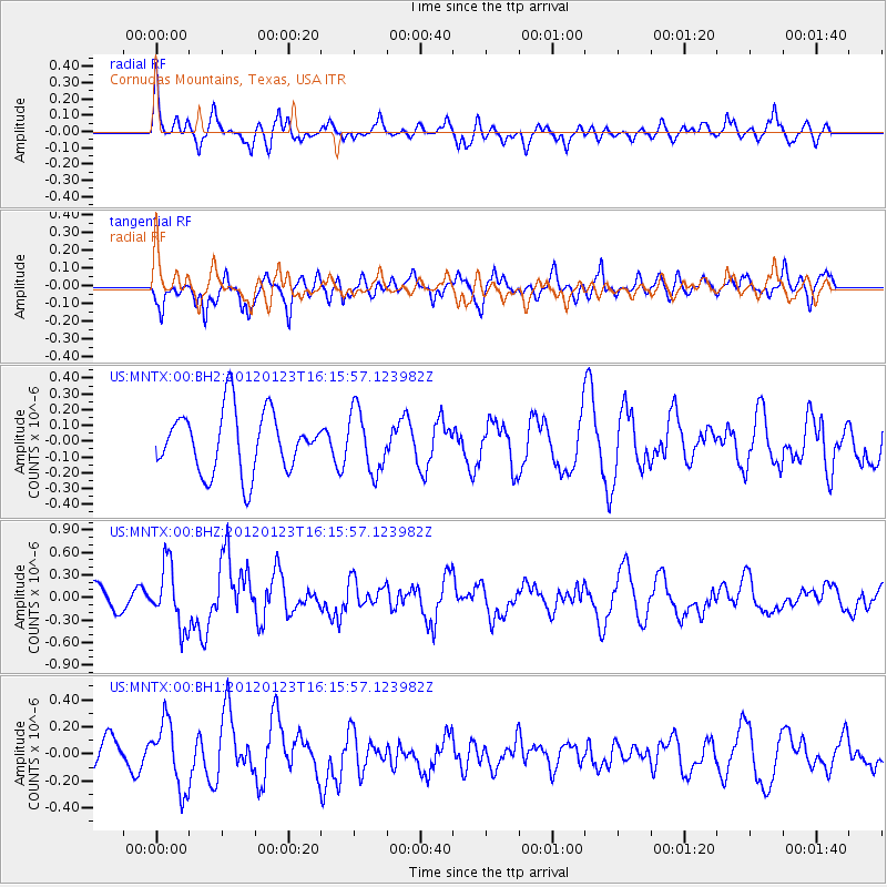
MNTX Cornudas Mountains, Texas, USA - Earthquake Result Viewer
*The percent match for this event was below the threshold and hence no stack was calculated.
| Earthquake location: |
Near Coast Of Central Chile |
| Earthquake latitude/longitude: |
-36.4/-73.0 |
| Earthquake time(UTC): |
2012/01/23 (023) 16:04:52 GMT |
| Earthquake Depth: |
20 km |
| Earthquake Magnitude: |
5.8 MB, 6.0 MS, 6.1 MW, 6.2 MW |
| Earthquake Catalog/Contributor: |
WHDF/NEIC |
|
| Network: |
US United States National Seismic Network |
| Station: |
MNTX Cornudas Mountains, Texas, USA |
| Lat/Lon: |
31.70 N/105.38 W |
| Elevation: |
404 m |
|
| Distance: |
74.2 deg |
| Az: |
331.706 deg |
| Baz: |
153.347 deg |
| Ray Param: |
$rayparam |
*The percent match for this event was below the threshold and hence was not used in the summary stack. |
|
| Radial Match: |
60.509056 % |
| Radial Bump: |
357 |
| Transverse Match: |
64.249916 % |
| Transverse Bump: |
400 |
| SOD ConfigId: |
558545 |
| Insert Time: |
2013-09-19 10:19:54.863 +0000 |
| GWidth: |
2.5 |
| Max Bumps: |
400 |
| Tol: |
0.001 |
|
Signal To Noise
| Channel | StoN | STA | LTA |
| US:MNTX:00:BHZ:20120123T16:15:57.123982Z | 3.0272312 | 4.0869597E-7 | 1.3500653E-7 |
| US:MNTX:00:BH1:20120123T16:15:57.123982Z | 1.5582547 | 2.4564756E-7 | 1.5764275E-7 |
| US:MNTX:00:BH2:20120123T16:15:57.123982Z | 1.0078591 | 1.9358399E-7 | 1.9207447E-7 |
| Arrivals |
| Ps | |
| PpPs | |
| PsPs/PpSs | |


