You are here: Home > Network List > II - Global Seismograph Network (GSN - IRIS/IDA) Stations List
> Station WRAB Tennant Creek, NT, Australia > Earthquake Result Viewer
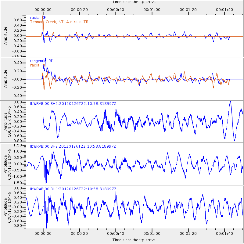
WRAB Tennant Creek, NT, Australia - Earthquake Result Viewer
*The percent match for this event was below the threshold and hence no stack was calculated.
| Earthquake location: |
Mariana Islands Region |
| Earthquake latitude/longitude: |
21.6/142.9 |
| Earthquake time(UTC): |
2012/01/26 (026) 22:04:06 GMT |
| Earthquake Depth: |
314 km |
| Earthquake Magnitude: |
5.5 MB, 5.3 MW |
| Earthquake Catalog/Contributor: |
WHDF/NEIC |
|
| Network: |
II Global Seismograph Network (GSN - IRIS/IDA) |
| Station: |
WRAB Tennant Creek, NT, Australia |
| Lat/Lon: |
19.93 S/134.36 E |
| Elevation: |
366 m |
|
| Distance: |
42.1 deg |
| Az: |
191.948 deg |
| Baz: |
11.813 deg |
| Ray Param: |
$rayparam |
*The percent match for this event was below the threshold and hence was not used in the summary stack. |
|
| Radial Match: |
60.537693 % |
| Radial Bump: |
400 |
| Transverse Match: |
68.88373 % |
| Transverse Bump: |
400 |
| SOD ConfigId: |
558545 |
| Insert Time: |
2013-09-19 10:27:13.509 +0000 |
| GWidth: |
2.5 |
| Max Bumps: |
400 |
| Tol: |
0.001 |
|
Signal To Noise
| Channel | StoN | STA | LTA |
| II:WRAB:00:BHZ:20120126T22:10:58.818997Z | 1.6516289 | 5.961368E-7 | 3.6093869E-7 |
| II:WRAB:00:BH1:20120126T22:10:58.818997Z | 1.1497456 | 3.2133863E-7 | 2.7948673E-7 |
| II:WRAB:00:BH2:20120126T22:10:58.818997Z | 0.9748831 | 2.3268873E-7 | 2.3868373E-7 |
| Arrivals |
| Ps | |
| PpPs | |
| PsPs/PpSs | |


