You are here: Home > Network List > IU - Global Seismograph Network (GSN - IRIS/USGS) Stations List
> Station MAKZ Makanchi, Kazakhstan > Earthquake Result Viewer
MAKZ Makanchi, Kazakhstan - Earthquake Result Viewer
*The percent match for this event was below the threshold and hence no stack was calculated.
| Earthquake location: |
Mariana Islands Region |
| Earthquake latitude/longitude: |
21.6/142.9 |
| Earthquake time(UTC): |
2012/01/26 (026) 22:04:06 GMT |
| Earthquake Depth: |
314 km |
| Earthquake Magnitude: |
5.5 MB, 5.3 MW |
| Earthquake Catalog/Contributor: |
WHDF/NEIC |
|
| Network: |
IU Global Seismograph Network (GSN - IRIS/USGS) |
| Station: |
MAKZ Makanchi, Kazakhstan |
| Lat/Lon: |
46.81 N/81.98 E |
| Elevation: |
600 m |
|
| Distance: |
54.7 deg |
| Az: |
312.692 deg |
| Baz: |
95.426 deg |
| Ray Param: |
$rayparam |
*The percent match for this event was below the threshold and hence was not used in the summary stack. |
|
| Radial Match: |
51.882153 % |
| Radial Bump: |
353 |
| Transverse Match: |
68.00152 % |
| Transverse Bump: |
400 |
| SOD ConfigId: |
558545 |
| Insert Time: |
2013-09-19 10:27:39.242 +0000 |
| GWidth: |
2.5 |
| Max Bumps: |
400 |
| Tol: |
0.001 |
|
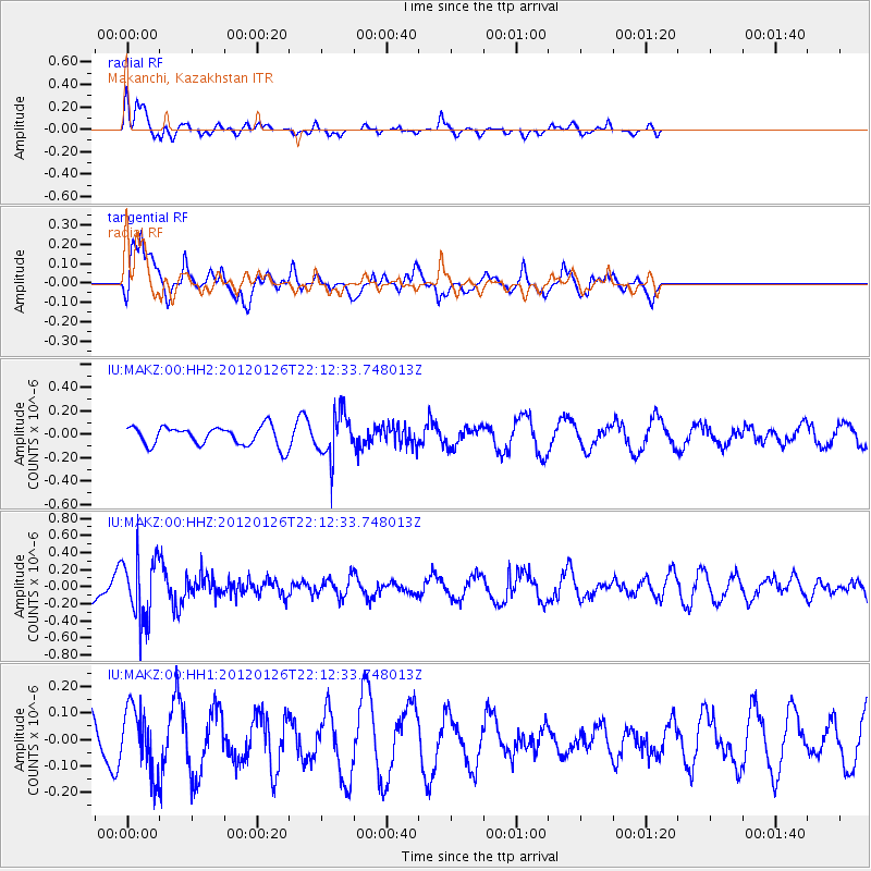
Signal To Noise
| Channel | StoN | STA | LTA |
| IU:MAKZ:00:HHZ:20120126T22:12:33.748013Z | 2.616216 | 3.6988567E-7 | 1.4138193E-7 |
| IU:MAKZ:00:HH1:20120126T22:12:33.748013Z | 2.0220141 | 1.197649E-7 | 5.92305E-8 |
| IU:MAKZ:00:HH2:20120126T22:12:33.748013Z | 2.3486445 | 1.9029417E-7 | 8.102298E-8 |
| Arrivals |
| Ps | |
| PpPs | |
| PsPs/PpSs | |


