You are here: Home > Network List > US - United States National Seismic Network Stations List
> Station OGNE Ogallala, Nebraska, USA > Earthquake Result Viewer
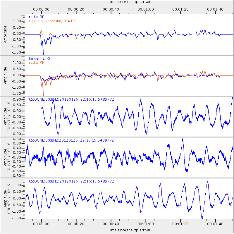
OGNE Ogallala, Nebraska, USA - Earthquake Result Viewer
*The percent match for this event was below the threshold and hence no stack was calculated.
| Earthquake location: |
Mariana Islands Region |
| Earthquake latitude/longitude: |
21.6/142.9 |
| Earthquake time(UTC): |
2012/01/26 (026) 22:04:06 GMT |
| Earthquake Depth: |
314 km |
| Earthquake Magnitude: |
5.5 MB, 5.3 MW |
| Earthquake Catalog/Contributor: |
WHDF/NEIC |
|
| Network: |
US United States National Seismic Network |
| Station: |
OGNE Ogallala, Nebraska, USA |
| Lat/Lon: |
40.95 N/102.03 W |
| Elevation: |
0.0 m |
|
| Distance: |
93.4 deg |
| Az: |
43.403 deg |
| Baz: |
302.448 deg |
| Ray Param: |
$rayparam |
*The percent match for this event was below the threshold and hence was not used in the summary stack. |
|
| Radial Match: |
54.222183 % |
| Radial Bump: |
400 |
| Transverse Match: |
32.821835 % |
| Transverse Bump: |
400 |
| SOD ConfigId: |
558545 |
| Insert Time: |
2013-09-19 10:28:24.161 +0000 |
| GWidth: |
2.5 |
| Max Bumps: |
400 |
| Tol: |
0.001 |
|
Signal To Noise
| Channel | StoN | STA | LTA |
| US:OGNE:00:BHZ:20120126T22:16:15.548977Z | 0.68636006 | 1.6708208E-7 | 2.434321E-7 |
| US:OGNE:00:BH1:20120126T22:16:15.548977Z | 1.2528949 | 6.7832264E-7 | 5.4140423E-7 |
| US:OGNE:00:BH2:20120126T22:16:15.548977Z | 0.68824565 | 2.590219E-7 | 3.7635093E-7 |
| Arrivals |
| Ps | |
| PpPs | |
| PsPs/PpSs | |


