You are here: Home > Network List > II - Global Seismograph Network (GSN - IRIS/IDA) Stations List
> Station WRAB Tennant Creek, NT, Australia > Earthquake Result Viewer
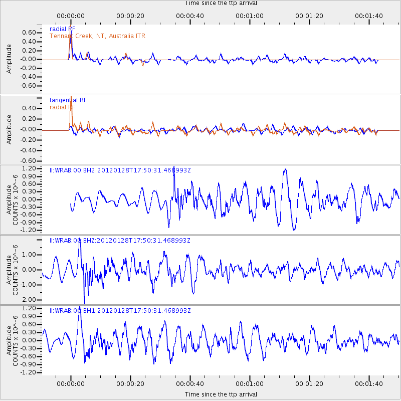
WRAB Tennant Creek, NT, Australia - Earthquake Result Viewer
*The percent match for this event was below the threshold and hence no stack was calculated.
| Earthquake location: |
Kermadec Islands, New Zealand |
| Earthquake latitude/longitude: |
-29.4/-177.4 |
| Earthquake time(UTC): |
2012/01/28 (028) 17:42:51 GMT |
| Earthquake Depth: |
21 km |
| Earthquake Magnitude: |
5.8 MB, 5.6 MS, 5.9 MW, 5.8 MW |
| Earthquake Catalog/Contributor: |
WHDF/NEIC |
|
| Network: |
II Global Seismograph Network (GSN - IRIS/IDA) |
| Station: |
WRAB Tennant Creek, NT, Australia |
| Lat/Lon: |
19.93 S/134.36 E |
| Elevation: |
366 m |
|
| Distance: |
44.6 deg |
| Az: |
270.863 deg |
| Baz: |
112.008 deg |
| Ray Param: |
$rayparam |
*The percent match for this event was below the threshold and hence was not used in the summary stack. |
|
| Radial Match: |
70.18356 % |
| Radial Bump: |
351 |
| Transverse Match: |
40.152763 % |
| Transverse Bump: |
400 |
| SOD ConfigId: |
558545 |
| Insert Time: |
2013-09-19 10:38:52.746 +0000 |
| GWidth: |
2.5 |
| Max Bumps: |
400 |
| Tol: |
0.001 |
|
Signal To Noise
| Channel | StoN | STA | LTA |
| II:WRAB:00:BHZ:20120128T17:50:31.468993Z | 2.5329752 | 9.5244053E-7 | 3.7601652E-7 |
| II:WRAB:00:BH1:20120128T17:50:31.468993Z | 1.8973967 | 5.8796377E-7 | 3.098792E-7 |
| II:WRAB:00:BH2:20120128T17:50:31.468993Z | 2.4080794 | 5.086864E-7 | 2.1124154E-7 |
| Arrivals |
| Ps | |
| PpPs | |
| PsPs/PpSs | |


