You are here: Home > Network List > CU - Caribbean Network (USGS) Stations List
> Station GRTK Grand Turk, Turks and Caicos Islands > Earthquake Result Viewer
GRTK Grand Turk, Turks and Caicos Islands - Earthquake Result Viewer
| Earthquake location: |
Near Coast Of Peru |
| Earthquake latitude/longitude: |
-14.2/-75.6 |
| Earthquake time(UTC): |
2012/01/30 (030) 05:11:00 GMT |
| Earthquake Depth: |
43 km |
| Earthquake Magnitude: |
6.3 MB, 5.9 MS, 6.4 MW, 6.4 MW |
| Earthquake Catalog/Contributor: |
WHDF/NEIC |
|
| Network: |
CU Caribbean Network (USGS) |
| Station: |
GRTK Grand Turk, Turks and Caicos Islands |
| Lat/Lon: |
21.51 N/71.13 W |
| Elevation: |
12 m |
|
| Distance: |
35.7 deg |
| Az: |
7.19 deg |
| Baz: |
187.492 deg |
| Ray Param: |
0.07696648 |
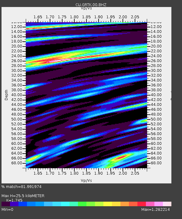
| Estimated Moho Depth: |
25.5 km |
| Estimated Crust Vp/Vs: |
1.75 |
| Assumed Crust Vp: |
4.452 km/s |
| Estimated Crust Vs: |
2.551 km/s |
| Estimated Crust Poisson's Ratio: |
0.26 |
|
| Radial Match: |
81.991974 % |
| Radial Bump: |
400 |
| Transverse Match: |
73.44012 % |
| Transverse Bump: |
400 |
| SOD ConfigId: |
558545 |
| Insert Time: |
2013-09-19 10:41:14.570 +0000 |
| GWidth: |
2.5 |
| Max Bumps: |
400 |
| Tol: |
0.001 |
|

Signal To Noise
| Channel | StoN | STA | LTA |
| CU:GRTK:00:BHZ:20120130T05:17:25.200Z | 5.2327056 | 3.137469E-6 | 5.995883E-7 |
| CU:GRTK:00:BH1:20120130T05:17:25.200Z | 1.919024 | 9.70711E-7 | 5.058357E-7 |
| CU:GRTK:00:BH2:20120130T05:17:25.200Z | 0.8947395 | 5.756513E-7 | 6.43373E-7 |
| Arrivals |
| Ps | 4.4 SECOND |
| PpPs | 15 SECOND |
| PsPs/PpSs | 20 SECOND |


