You are here: Home > Network List > IU - Global Seismograph Network (GSN - IRIS/USGS) Stations List
> Station TEIG Tepich, Yucatan, Mexico > Earthquake Result Viewer
TEIG Tepich, Yucatan, Mexico - Earthquake Result Viewer
| Earthquake location: |
Near Coast Of Peru |
| Earthquake latitude/longitude: |
-14.2/-75.6 |
| Earthquake time(UTC): |
2012/01/30 (030) 05:11:00 GMT |
| Earthquake Depth: |
43 km |
| Earthquake Magnitude: |
6.3 MB, 5.9 MS, 6.4 MW, 6.4 MW |
| Earthquake Catalog/Contributor: |
WHDF/NEIC |
|
| Network: |
IU Global Seismograph Network (GSN - IRIS/USGS) |
| Station: |
TEIG Tepich, Yucatan, Mexico |
| Lat/Lon: |
20.23 N/88.28 W |
| Elevation: |
40 m |
|
| Distance: |
36.4 deg |
| Az: |
339.722 deg |
| Baz: |
159.024 deg |
| Ray Param: |
0.0766197 |
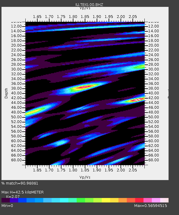
| Estimated Moho Depth: |
42.5 km |
| Estimated Crust Vp/Vs: |
2.07 |
| Assumed Crust Vp: |
5.817 km/s |
| Estimated Crust Vs: |
2.81 km/s |
| Estimated Crust Poisson's Ratio: |
0.35 |
|
| Radial Match: |
90.96861 % |
| Radial Bump: |
400 |
| Transverse Match: |
91.020035 % |
| Transverse Bump: |
400 |
| SOD ConfigId: |
558545 |
| Insert Time: |
2013-09-19 10:42:37.354 +0000 |
| GWidth: |
2.5 |
| Max Bumps: |
400 |
| Tol: |
0.001 |
|

Signal To Noise
| Channel | StoN | STA | LTA |
| IU:TEIG:00:BHZ:20120130T05:17:30.659991Z | 8.898832 | 3.1744921E-6 | 3.5673128E-7 |
| IU:TEIG:00:BH1:20120130T05:17:30.659991Z | 1.2383554 | 2.4879087E-8 | 2.0090425E-8 |
| IU:TEIG:00:BH2:20120130T05:17:30.659991Z | 4.7147064 | 1.2954898E-6 | 2.747763E-7 |
| Arrivals |
| Ps | 8.2 SECOND |
| PpPs | 21 SECOND |
| PsPs/PpSs | 30 SECOND |


