You are here: Home > Network List > US - United States National Seismic Network Stations List
> Station AMTX Amarillo, Texas, USA > Earthquake Result Viewer
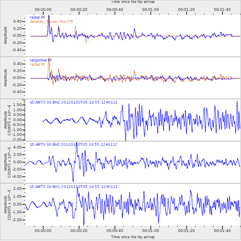
AMTX Amarillo, Texas, USA - Earthquake Result Viewer
*The percent match for this event was below the threshold and hence no stack was calculated.
| Earthquake location: |
Near Coast Of Peru |
| Earthquake latitude/longitude: |
-14.2/-75.6 |
| Earthquake time(UTC): |
2012/01/30 (030) 05:11:00 GMT |
| Earthquake Depth: |
43 km |
| Earthquake Magnitude: |
6.3 MB, 5.9 MS, 6.4 MW, 6.4 MW |
| Earthquake Catalog/Contributor: |
WHDF/NEIC |
|
| Network: |
US United States National Seismic Network |
| Station: |
AMTX Amarillo, Texas, USA |
| Lat/Lon: |
34.53 N/101.41 W |
| Elevation: |
1010 m |
|
| Distance: |
54.3 deg |
| Az: |
333.756 deg |
| Baz: |
148.7 deg |
| Ray Param: |
$rayparam |
*The percent match for this event was below the threshold and hence was not used in the summary stack. |
|
| Radial Match: |
86.00918 % |
| Radial Bump: |
400 |
| Transverse Match: |
67.36705 % |
| Transverse Bump: |
400 |
| SOD ConfigId: |
558545 |
| Insert Time: |
2013-09-19 10:42:59.344 +0000 |
| GWidth: |
2.5 |
| Max Bumps: |
400 |
| Tol: |
0.001 |
|
Signal To Noise
| Channel | StoN | STA | LTA |
| US:AMTX:00:BHZ:20120130T05:19:55.124011Z | 2.2518477 | 5.7025994E-7 | 2.532409E-7 |
| US:AMTX:00:BH1:20120130T05:19:55.124011Z | 0.84556186 | 1.9138379E-7 | 2.263392E-7 |
| US:AMTX:00:BH2:20120130T05:19:55.124011Z | 0.97198766 | 1.5026741E-7 | 1.5459806E-7 |
| Arrivals |
| Ps | |
| PpPs | |
| PsPs/PpSs | |


