You are here: Home > Network List > US - United States National Seismic Network Stations List
> Station CNNC Cliffs of the Neuse, North Carolina, USA > Earthquake Result Viewer
CNNC Cliffs of the Neuse, North Carolina, USA - Earthquake Result Viewer
| Earthquake location: |
Near Coast Of Peru |
| Earthquake latitude/longitude: |
-14.2/-75.6 |
| Earthquake time(UTC): |
2012/01/30 (030) 05:11:00 GMT |
| Earthquake Depth: |
43 km |
| Earthquake Magnitude: |
6.3 MB, 5.9 MS, 6.4 MW, 6.4 MW |
| Earthquake Catalog/Contributor: |
WHDF/NEIC |
|
| Network: |
US United States National Seismic Network |
| Station: |
CNNC Cliffs of the Neuse, North Carolina, USA |
| Lat/Lon: |
35.24 N/77.88 W |
| Elevation: |
17 m |
|
| Distance: |
49.2 deg |
| Az: |
357.572 deg |
| Baz: |
177.122 deg |
| Ray Param: |
0.0687641 |
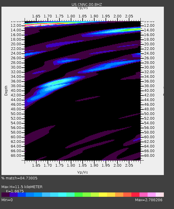
| Estimated Moho Depth: |
11.5 km |
| Estimated Crust Vp/Vs: |
1.67 |
| Assumed Crust Vp: |
6.565 km/s |
| Estimated Crust Vs: |
3.937 km/s |
| Estimated Crust Poisson's Ratio: |
0.22 |
|
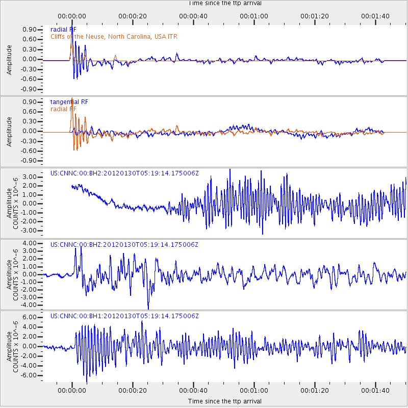
| Radial Match: |
84.73805 % |
| Radial Bump: |
400 |
| Transverse Match: |
26.431614 % |
| Transverse Bump: |
400 |
| SOD ConfigId: |
558545 |
| Insert Time: |
2013-09-19 10:43:19.646 +0000 |
| GWidth: |
2.5 |
| Max Bumps: |
400 |
| Tol: |
0.001 |
|
Signal To Noise
| Channel | StoN | STA | LTA |
| US:CNNC:00:BHZ:20120130T05:19:14.175006Z | 9.584056 | 1.5292056E-6 | 1.5955725E-7 |
| US:CNNC:00:BH1:20120130T05:19:14.175006Z | 10.866851 | 2.6195776E-6 | 2.4106131E-7 |
| US:CNNC:00:BH2:20120130T05:19:14.175006Z | 1.1487358 | 1.0067703E-6 | 8.764159E-7 |
| Arrivals |
| Ps | 1.2 SECOND |
| PpPs | 4.4 SECOND |
| PsPs/PpSs | 5.6 SECOND |


