You are here: Home > Network List > IU - Global Seismograph Network (GSN - IRIS/USGS) Stations List
> Station JOHN Johnston Island, USA > Earthquake Result Viewer
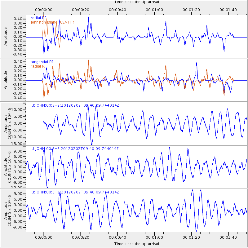
JOHN Johnston Island, USA - Earthquake Result Viewer
*The percent match for this event was below the threshold and hence no stack was calculated.
| Earthquake location: |
New Britain Region, P.N.G. |
| Earthquake latitude/longitude: |
-6.6/149.7 |
| Earthquake time(UTC): |
2012/02/02 (033) 09:32:16 GMT |
| Earthquake Depth: |
39 km |
| Earthquake Magnitude: |
5.6 MW |
| Earthquake Catalog/Contributor: |
NEIC PDE/NEIC PDE-M |
|
| Network: |
IU Global Seismograph Network (GSN - IRIS/USGS) |
| Station: |
JOHN Johnston Island, USA |
| Lat/Lon: |
16.73 N/169.53 W |
| Elevation: |
2.0 m |
|
| Distance: |
46.5 deg |
| Az: |
59.6 deg |
| Baz: |
243.417 deg |
| Ray Param: |
$rayparam |
*The percent match for this event was below the threshold and hence was not used in the summary stack. |
|
| Radial Match: |
48.705505 % |
| Radial Bump: |
366 |
| Transverse Match: |
45.83244 % |
| Transverse Bump: |
384 |
| SOD ConfigId: |
558545 |
| Insert Time: |
2013-09-19 10:50:08.846 +0000 |
| GWidth: |
2.5 |
| Max Bumps: |
400 |
| Tol: |
0.001 |
|
Signal To Noise
| Channel | StoN | STA | LTA |
| IU:JOHN:00:BHZ:20120202T09:40:09.744014Z | 3.5828416 | 8.2105935E-6 | 2.2916429E-6 |
| IU:JOHN:00:BH1:20120202T09:40:09.744014Z | 0.78372693 | 3.0381818E-6 | 3.876582E-6 |
| IU:JOHN:00:BH2:20120202T09:40:09.744014Z | 1.094601 | 5.0829267E-6 | 4.6436344E-6 |
| Arrivals |
| Ps | |
| PpPs | |
| PsPs/PpSs | |


