You are here: Home > Network List > G - GEOSCOPE Stations List
> Station KIP Kipapa - Hawaii, USA > Earthquake Result Viewer
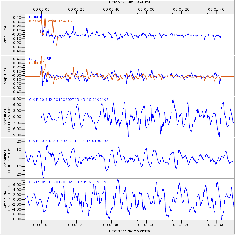
KIP Kipapa - Hawaii, USA - Earthquake Result Viewer
*The percent match for this event was below the threshold and hence no stack was calculated.
| Earthquake location: |
Vanuatu Islands |
| Earthquake latitude/longitude: |
-17.8/167.1 |
| Earthquake time(UTC): |
2012/02/02 (033) 13:34:40 GMT |
| Earthquake Depth: |
23 km |
| Earthquake Magnitude: |
6.5 MB, 6.9 MS, 7.1 MW, 7.1 MW |
| Earthquake Catalog/Contributor: |
WHDF/NEIC |
|
| Network: |
G GEOSCOPE |
| Station: |
KIP Kipapa - Hawaii, USA |
| Lat/Lon: |
21.42 N/158.01 W |
| Elevation: |
70 m |
|
| Distance: |
51.8 deg |
| Az: |
42.623 deg |
| Baz: |
223.814 deg |
| Ray Param: |
$rayparam |
*The percent match for this event was below the threshold and hence was not used in the summary stack. |
|
| Radial Match: |
74.30121 % |
| Radial Bump: |
400 |
| Transverse Match: |
75.86524 % |
| Transverse Bump: |
400 |
| SOD ConfigId: |
558545 |
| Insert Time: |
2013-09-19 10:52:20.752 +0000 |
| GWidth: |
2.5 |
| Max Bumps: |
400 |
| Tol: |
0.001 |
|
Signal To Noise
| Channel | StoN | STA | LTA |
| G:KIP:00:BHZ:20120202T13:43:16.019019Z | 2.5532331 | 1.2628764E-5 | 4.946185E-6 |
| G:KIP:00:BH1:20120202T13:43:16.019019Z | 1.3088882 | 2.8329787E-6 | 2.1644162E-6 |
| G:KIP:00:BH2:20120202T13:43:16.019019Z | 1.3446829 | 3.6855454E-6 | 2.7408284E-6 |
| Arrivals |
| Ps | |
| PpPs | |
| PsPs/PpSs | |


