You are here: Home > Network List > IU - Global Seismograph Network (GSN - IRIS/USGS) Stations List
> Station JOHN Johnston Island, USA > Earthquake Result Viewer
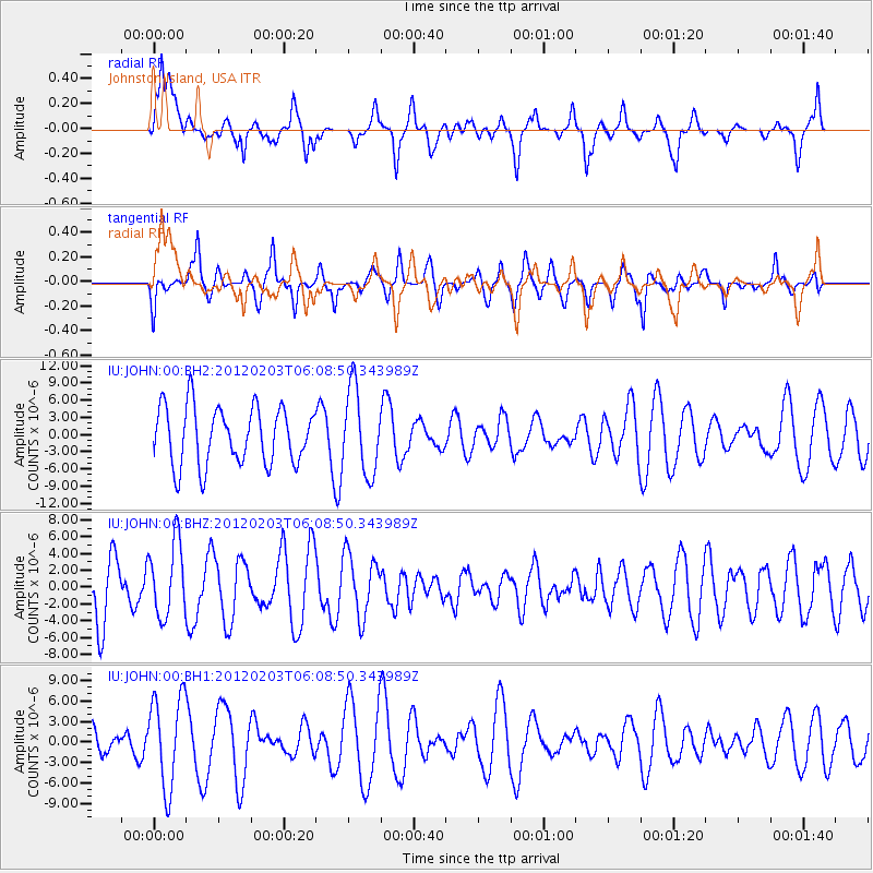
JOHN Johnston Island, USA - Earthquake Result Viewer
*The percent match for this event was below the threshold and hence no stack was calculated.
| Earthquake location: |
Vanuatu Islands |
| Earthquake latitude/longitude: |
-17.4/167.2 |
| Earthquake time(UTC): |
2012/02/03 (034) 06:01:38 GMT |
| Earthquake Depth: |
10 km |
| Earthquake Magnitude: |
5.6 MB, 5.3 MS, 5.4 MW, 5.5 MW |
| Earthquake Catalog/Contributor: |
WHDF/NEIC |
|
| Network: |
IU Global Seismograph Network (GSN - IRIS/USGS) |
| Station: |
JOHN Johnston Island, USA |
| Lat/Lon: |
16.73 N/169.53 W |
| Elevation: |
2.0 m |
|
| Distance: |
40.9 deg |
| Az: |
35.262 deg |
| Baz: |
215.123 deg |
| Ray Param: |
$rayparam |
*The percent match for this event was below the threshold and hence was not used in the summary stack. |
|
| Radial Match: |
52.67419 % |
| Radial Bump: |
400 |
| Transverse Match: |
48.566383 % |
| Transverse Bump: |
344 |
| SOD ConfigId: |
558545 |
| Insert Time: |
2013-09-19 11:02:34.226 +0000 |
| GWidth: |
2.5 |
| Max Bumps: |
400 |
| Tol: |
0.001 |
|
Signal To Noise
| Channel | StoN | STA | LTA |
| IU:JOHN:00:BHZ:20120203T06:08:50.343989Z | 1.3162812 | 4.3956757E-6 | 3.3394654E-6 |
| IU:JOHN:00:BH1:20120203T06:08:50.343989Z | 2.9559908 | 6.7238375E-6 | 2.2746476E-6 |
| IU:JOHN:00:BH2:20120203T06:08:50.343989Z | 1.4684764 | 7.3709552E-6 | 5.0194576E-6 |
| Arrivals |
| Ps | |
| PpPs | |
| PsPs/PpSs | |


