You are here: Home > Network List > II - Global Seismograph Network (GSN - IRIS/IDA) Stations List
> Station PALK Pallekele, Sri Lanka > Earthquake Result Viewer
PALK Pallekele, Sri Lanka - Earthquake Result Viewer
| Earthquake location: |
Negros, Philippines |
| Earthquake latitude/longitude: |
10.0/123.2 |
| Earthquake time(UTC): |
2012/02/06 (037) 03:49:12 GMT |
| Earthquake Depth: |
11 km |
| Earthquake Magnitude: |
6.3 MB, 6.6 MS, 6.7 MW, 6.7 MW |
| Earthquake Catalog/Contributor: |
WHDF/NEIC |
|
| Network: |
II Global Seismograph Network (GSN - IRIS/IDA) |
| Station: |
PALK Pallekele, Sri Lanka |
| Lat/Lon: |
7.27 N/80.70 E |
| Elevation: |
460 m |
|
| Distance: |
42.1 deg |
| Az: |
269.804 deg |
| Baz: |
83.162 deg |
| Ray Param: |
0.07337487 |
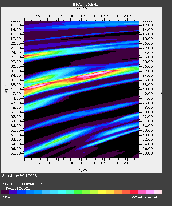
| Estimated Moho Depth: |
33.0 km |
| Estimated Crust Vp/Vs: |
1.91 |
| Assumed Crust Vp: |
6.545 km/s |
| Estimated Crust Vs: |
3.427 km/s |
| Estimated Crust Poisson's Ratio: |
0.31 |
|
| Radial Match: |
90.17698 % |
| Radial Bump: |
380 |
| Transverse Match: |
60.559555 % |
| Transverse Bump: |
400 |
| SOD ConfigId: |
558545 |
| Insert Time: |
2013-09-19 11:16:50.302 +0000 |
| GWidth: |
2.5 |
| Max Bumps: |
400 |
| Tol: |
0.001 |
|
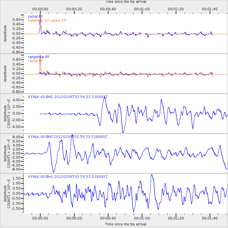
Signal To Noise
| Channel | StoN | STA | LTA |
| II:PALK:00:BHZ:20120206T03:56:33.518993Z | 6.7193847 | 1.2131209E-6 | 1.8054047E-7 |
| II:PALK:00:BH1:20120206T03:56:33.518993Z | 1.3797951 | 1.6501359E-7 | 1.1959283E-7 |
| II:PALK:00:BH2:20120206T03:56:33.518993Z | 5.471756 | 7.838432E-7 | 1.4325259E-7 |
| Arrivals |
| Ps | 4.9 SECOND |
| PpPs | 14 SECOND |
| PsPs/PpSs | 19 SECOND |


