You are here: Home > Network List > IU - Global Seismograph Network (GSN - IRIS/USGS) Stations List
> Station GNI Garni, Armenia > Earthquake Result Viewer
GNI Garni, Armenia - Earthquake Result Viewer
| Earthquake location: |
Negros, Philippines |
| Earthquake latitude/longitude: |
10.0/123.2 |
| Earthquake time(UTC): |
2012/02/06 (037) 03:49:12 GMT |
| Earthquake Depth: |
11 km |
| Earthquake Magnitude: |
6.3 MB, 6.6 MS, 6.7 MW, 6.7 MW |
| Earthquake Catalog/Contributor: |
WHDF/NEIC |
|
| Network: |
IU Global Seismograph Network (GSN - IRIS/USGS) |
| Station: |
GNI Garni, Armenia |
| Lat/Lon: |
40.15 N/44.74 E |
| Elevation: |
1609 m |
|
| Distance: |
74.8 deg |
| Az: |
308.907 deg |
| Baz: |
89.66 deg |
| Ray Param: |
0.052071303 |
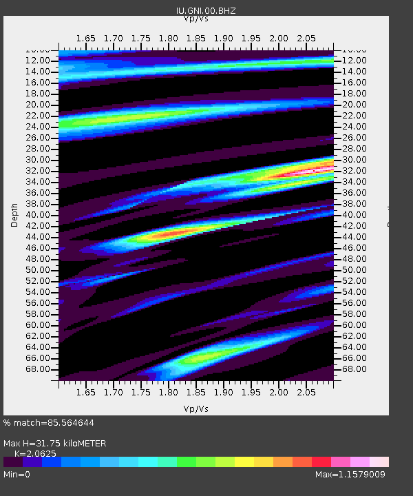
| Estimated Moho Depth: |
31.75 km |
| Estimated Crust Vp/Vs: |
2.06 |
| Assumed Crust Vp: |
6.291 km/s |
| Estimated Crust Vs: |
3.05 km/s |
| Estimated Crust Poisson's Ratio: |
0.35 |
|
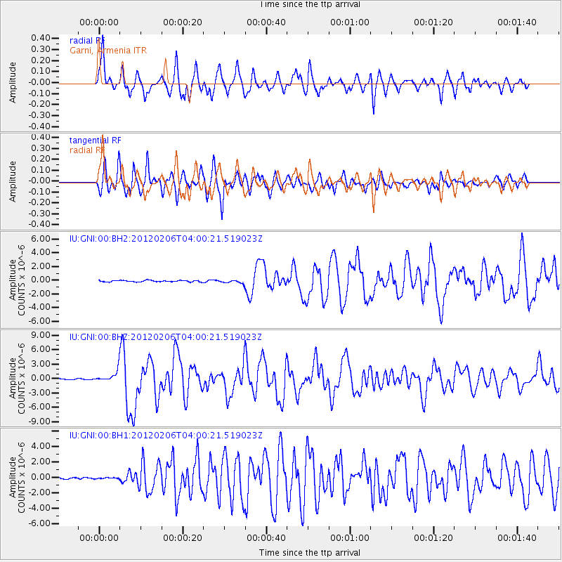
| Radial Match: |
85.564644 % |
| Radial Bump: |
400 |
| Transverse Match: |
87.28688 % |
| Transverse Bump: |
400 |
| SOD ConfigId: |
558545 |
| Insert Time: |
2013-09-19 11:17:06.056 +0000 |
| GWidth: |
2.5 |
| Max Bumps: |
400 |
| Tol: |
0.001 |
|
Signal To Noise
| Channel | StoN | STA | LTA |
| IU:GNI:00:BHZ:20120206T04:00:21.519023Z | 16.972795 | 1.3889875E-6 | 8.1836106E-8 |
| IU:GNI:00:BH1:20120206T04:00:21.519023Z | 0.61845833 | 6.074857E-8 | 9.8225804E-8 |
| IU:GNI:00:BH2:20120206T04:00:21.519023Z | 2.3984323 | 2.5046862E-7 | 1.0443014E-7 |
| Arrivals |
| Ps | 5.5 SECOND |
| PpPs | 15 SECOND |
| PsPs/PpSs | 21 SECOND |


